On Tuesday
October 17,th 2017, a powerful wind event wreaked havoc across much
of the southern half of Alberta during the afternoon and evening hours. The
main problems came from the ignition and rapid spread of grassfires, which
impacted numerous communities across the south – with many residents facing
mandatory (albeit temporary) evacuation orders. Even though widespread
structural damage was avoided, several buildings including homes were
destroyed, along with other losses of property, livestock and wildlife.
Unfortunately, one fatality involving a volunteer firefighter and another serious injury occurred as a result of the
grassfires near Hilda.
 |
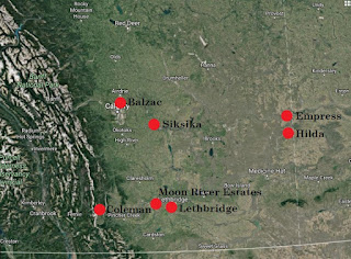
| Here is an unofficial map of the grassfires created using Google Earth. These were the main fires or areas of fires (since several were clustered in the Siksika/Gleichen/Carseland area) that impacted communities in some way. Note that only Alberta fires are shown (since others occurred to the east); the fires near Hilda and Empress led to the evacuation of several communities in southwest Saskatchewan. |
The
wind also caused widespread power outages that affected thousands of customers
across Alberta, led to the derailment of two trains (one near Wainwright and
another near Trochu), flipped several big rigs on major roadways, and caused
damage to numerous trees during the latter half of the day on Tuesday. There
would have undoubtedly been more damage to deciduous trees had more foliage
remained, which would have caused even more trees to uproot that could cause
more damage to property and powerlines. As well, parts of city streets in
downtown Calgary were blocked off due to concerns of debris flying off of
skyscrapers. While Wind Warnings had been issued for the affected areas several
hours in advance, I’m not quite sure anyone anticipated the scale of problems
the winds would create. The storm would rapidly progress across the prairie
provinces overnight and into the next day, where high winds would continue to cause
damage and help spark wildfires.
 |
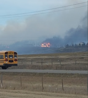
| Photo: Artur Pyzalski. One family lost their home and two dogs in a grassfire near Balzac, just north of Calgary, due to what was determined to be a carelessly discarded cigarette butt. |
 |
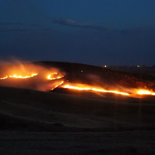
| Photo: Lethbridge News Now. Grassfires in the coulees of Lethbridge came perilously close to communities in the city's south. |
The
main culprit of the wind was an intense mid-latitude cyclone, that would
rapidly deepen as it departed the lee of the Rockies of western Alberta – being
supported by a highly energetic upper wave that was transiting through westerly
flow aloft across western Canada. During the spring and fall, greater thermal
contrasts typically exist in closer proximity compared with the rest of the
year, which, in a nutshell, can act to intensify the dynamics of such weather
systems. Indeed, very strong mid-level jet streams were associated with this
particular system, and a rapidly deepening surface low would contribute to the
strengthening pressure gradient that would ultimately be responsible for the
widespread, tremendous surface winds – both within the warm sector, and
following cold frontal passage of this frontal system.
 |
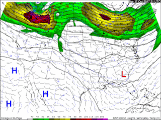
| RAP 21Z Oct 17 500mb Mesoanalysis. A ~110kt H5 speed maximum over northern Washington reveals the potency of this highly progressive shortwave trough. Courtesy COD. |
 |
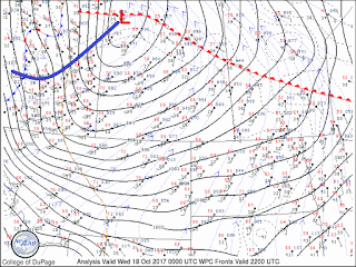
| 00Z Surface analysis (3 hours after the previous image) reveals a ~982mb surface low over western Saskatchewan. The low is the surface reflection of the strong upper divergence associated with the shortwave trough, and is still deepening during this time. Since fronts are auto-analyzed, the thick blue line has been added to show the more accurate position of the cold front at 00Z, when most fires were ongoing. Of particular note here is the tremendous MSLP gradient, which is responsible for the widespread strong winds. Courtesy COD. |
Now,
we take a closer look at environmental factors that led to the ignition of the
numerous, rapidly spreading wildfires across southern Alberta – in order that
we may better anticipate future occurrences, with the hope of being able to
enact some preventative measures as a result.
One
of the main factors that led to this wildfire outbreak was the time of year.
Earlier, it’s already been postulated that certain types of weather systems can
often be more intense during the spring and fall. But here in Alberta, we’re
also often quite “brown” at those times of year – especially in spring, before
“green-up” occurs. In April and early May, most or all snow has melted, the
rapidly intensifying sun is drying out the ground, precipitation is sparse
prior to the “June monsoon” (later spring rains), and the sap has yet to begin
flowing up into the trees. In forestry, this is known as the “spring dip”,
which is characterized by the low foliar
moisture content of the trees during this time. Thus, on warm, dry, gusty
days in this environment, we typically see the highest fire hazard. These factors
are of course less in fall (aside from brown, non-snow-covered grass), and this
year in particular saw great fire hazard persisting throughout the summer, due
to being anomalously hot and dry.
However,
had a wind event like this occurred over the greener fields of early summer, or
the frozen, snow-covered earth in winter, we wouldn’t have seen a rash of
grassfires (though we could have seen other types of problems). Early spring,
possibly late summer (when widespread wind events like this are uncommon), and
fall are really the main windows of time when these ingredients come together.
Even after substantial precipitation events, fine fuels such as dead grass can
quickly dry out to the point where it can easily ignite again in short order.
And
that was the key to the fire behaviour we witnessed on October 17th.
The dry, dead grasses were already a potential powderkeg, but the exceedingly
high winds greatly exacerbated the situation. When compared with other types of
wildland fires that consume a wider range of fuel sources, the conditions
required for this event are far more easily attained during the spring and
fall. Large, destructive forest fires often result as a culmination of factors
that have conspired for several months or even years in advance, such as in the
recent, memorable spring of 2016. Previously dry winters, along with
comparatively warm and dry springs, really help to dry out larger fuel sources
as well as the surface duff layer itself, going down a few feet in some cases.
This leads to deeper, hotter burning fires under the right conditions, which
can take months or even years to extinguish (like the Fort McMurray fires). By
contrast, grassfires and other types of surface fires that consume small,
flashy fuels, derive their intensity by the degree to which they’re driven by
the wind. They can spread much more rapidly in some cases, but are also
extinguished far more easily.
Smaller
diameter fuels such as dead grass, surface litter, leaves, and conifer needles,
have a much shorter timelag constant than
those of larger fuels, and those deeper within the ground. The timelag constant
is specifically the amount of time it takes a given fuel size/type to lose 2/3
of its moisture; soaked fuels with diameters of greater than 7cm typically
require as many as 7 weeks of dry conditions in the warm season to dry out
sufficiently to support combustion, while fine fuels such as dead, standing
grass can take less than a day. Smaller fuels are thus much more sensitive to
the weather, including wind and relative humidity, while larger fuels tend to
only be sensitive to appreciable amounts of precipitation as well as
temperature. The Canadian Wildland Fire Information System (CWFIS) has
developed a set of indices that take these factors into considering in
anticipating fire behaviour, called the Fire Weather Index (FWI) system:
Without
getting too deeply into it, the FFMC value corresponds to finer fuels, while
the DMC and DC correspond to progressively larger and deeper fuels
respectively. Moreover, “ISI-driven” fires result from the dryness of finer
fuels (and of course can also result when larger fuels are dry) as well as
wind, and “BUI-driven” fires result from longer term drought conditions that
dry out larger and deeper fuels. Thus, the fires of October 17th
were most certainly ISI-driven, due in large part to the fires burning
predominantly over grasslands.
 |
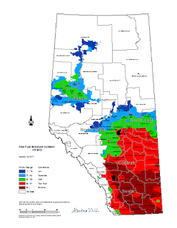
| Forecast FFMC values for October 16th - a day prior to the fires (since a map for the 17th wasn't available). Note there are already extreme values in excess of 92 across the southern Alberta grassland region. This and the following map are courtesy of ACIS, which can be found here. |


