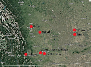
On Tuesday
October 17,th 2017, a powerful wind event wreaked havoc across much
of the southern half of Alberta during the afternoon and evening hours. The
main problems came from the ignition and rapid spread of grassfires, which
impacted numerous communities across the south – with many residents facing
mandatory (albeit temporary) evacuation orders. Even though widespread
structural damage was avoided, several buildings including homes were
destroyed, along with other losses of property, livestock and wildlife.
Unfortunately, one fatality involving a volunteer firefighter and another serious injury occurred as a result of the
grassfires near Hilda.
The wind also caused widespread power outages that affected thousands of customers across Alberta, led to the derailment of two trains (one near Wainwright and another near Trochu), flipped several big rigs on major roadways, and caused damage to numerous trees during the latter half of the day on Tuesday. There would have undoubtedly been more damage to deciduous trees had more foliage remained, which would have caused even more trees to uproot that could cause more damage to property and powerlines. As well, parts of city streets in downtown Calgary were blocked off due to concerns of debris flying off of skyscrapers. While Wind Warnings had been issued for the affected areas several hours in advance, I’m not quite sure anyone anticipated the scale of problems the winds would create. The storm would rapidly progress across the prairie provinces overnight and into the next day, where high winds would continue to cause damage and help spark wildfires.
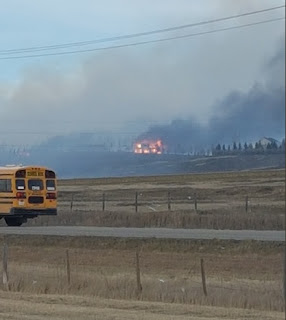 |
| Photo: Artur Pyzalski. One family lost their home and two dogs in a grassfire near Balzac, just north of Calgary, due to what was determined to be a carelessly discarded cigarette butt. |
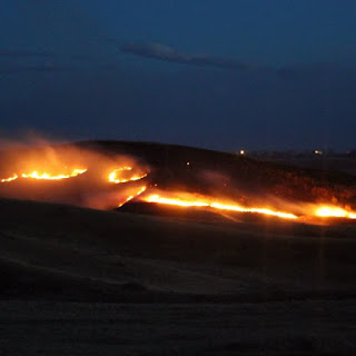 |
| Photo: Lethbridge News Now. Grassfires in the coulees of Lethbridge came perilously close to communities in the city's south. |
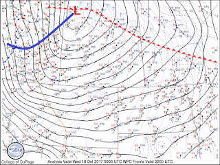
The
main culprit of the wind was an intense mid-latitude cyclone, that would
rapidly deepen as it departed the lee of the Rockies of western Alberta – being
supported by a highly energetic upper wave that was transiting through westerly
flow aloft across western Canada. During the spring and fall, greater thermal
contrasts typically exist in closer proximity compared with the rest of the
year, which, in a nutshell, can act to intensify the dynamics of such weather
systems. Indeed, very strong mid-level jet streams were associated with this
particular system, and a rapidly deepening surface low would contribute to the
strengthening pressure gradient that would ultimately be responsible for the
widespread, tremendous surface winds – both within the warm sector, and
following cold frontal passage of this frontal system.
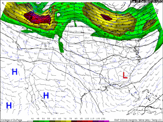 |
| RAP 21Z Oct 17 500mb Mesoanalysis. A ~110kt H5 speed maximum over northern Washington reveals the potency of this highly progressive shortwave trough. Courtesy COD. |
Now,
we take a closer look at environmental factors that led to the ignition of the
numerous, rapidly spreading wildfires across southern Alberta – in order that
we may better anticipate future occurrences, with the hope of being able to
enact some preventative measures as a result.
One
of the main factors that led to this wildfire outbreak was the time of year.
Earlier, it’s already been postulated that certain types of weather systems can
often be more intense during the spring and fall. But here in Alberta, we’re
also often quite “brown” at those times of year – especially in spring, before
“green-up” occurs. In April and early May, most or all snow has melted, the
rapidly intensifying sun is drying out the ground, precipitation is sparse
prior to the “June monsoon” (later spring rains), and the sap has yet to begin
flowing up into the trees. In forestry, this is known as the “spring dip”,
which is characterized by the low foliar
moisture content of the trees during this time. Thus, on warm, dry, gusty
days in this environment, we typically see the highest fire hazard. These factors
are of course less in fall (aside from brown, non-snow-covered grass), and this
year in particular saw great fire hazard persisting throughout the summer, due
to being anomalously hot and dry.
However, had a wind event like this occurred over the greener fields of early summer, or the frozen, snow-covered earth in winter, we wouldn’t have seen a rash of grassfires (though we could have seen other types of problems). Early spring, possibly late summer (when widespread wind events like this are uncommon), and fall are really the main windows of time when these ingredients come together. Even after substantial precipitation events, fine fuels such as dead grass can quickly dry out to the point where it can easily ignite again in short order.
And that was the key to the fire behaviour we witnessed on October 17th. The dry, dead grasses were already a potential powderkeg, but the exceedingly high winds greatly exacerbated the situation. When compared with other types of wildland fires that consume a wider range of fuel sources, the conditions required for this event are far more easily attained during the spring and fall. Large, destructive forest fires often result as a culmination of factors that have conspired for several months or even years in advance, such as in the recent, memorable spring of 2016. Previously dry winters, along with comparatively warm and dry springs, really help to dry out larger fuel sources as well as the surface duff layer itself, going down a few feet in some cases. This leads to deeper, hotter burning fires under the right conditions, which can take months or even years to extinguish (like the Fort McMurray fires). By contrast, grassfires and other types of surface fires that consume small, flashy fuels, derive their intensity by the degree to which they’re driven by the wind. They can spread much more rapidly in some cases, but are also extinguished far more easily.
Smaller diameter fuels such as dead grass, surface litter, leaves, and conifer needles, have a much shorter timelag constant than those of larger fuels, and those deeper within the ground. The timelag constant is specifically the amount of time it takes a given fuel size/type to lose 2/3 of its moisture; soaked fuels with diameters of greater than 7cm typically require as many as 7 weeks of dry conditions in the warm season to dry out sufficiently to support combustion, while fine fuels such as dead, standing grass can take less than a day. Smaller fuels are thus much more sensitive to the weather, including wind and relative humidity, while larger fuels tend to only be sensitive to appreciable amounts of precipitation as well as temperature. The Canadian Wildland Fire Information System (CWFIS) has developed a set of indices that take these factors into considering in anticipating fire behaviour, called the Fire Weather Index (FWI) system:
 |
| FWI Structure. For more information, check out this link. |
Without
getting too deeply into it, the FFMC value corresponds to finer fuels, while
the DMC and DC correspond to progressively larger and deeper fuels
respectively. Moreover, “ISI-driven” fires result from the dryness of finer
fuels (and of course can also result when larger fuels are dry) as well as
wind, and “BUI-driven” fires result from longer term drought conditions that
dry out larger and deeper fuels. Thus, the fires of October 17th
were most certainly ISI-driven, due in large part to the fires burning
predominantly over grasslands.
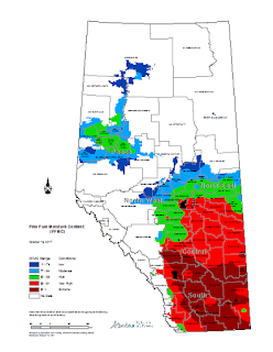 |
| Forecast FFMC values for October 16th - a day prior to the fires (since a map for the 17th wasn't available). Note there are already extreme values in excess of 92 across the southern Alberta grassland region. This and the following map are courtesy of ACIS, which can be found here. |
 |
| The above factors are clearly contributing to the extreme fire danger forecast here, valid for October 17th. These factors, combined with the wind warning, were a clear sign that a potential grassfire outbreak was possible. Courtesy NRC; this information can be found here. |
The
forward rates of spread are the direct result of the wind over grass that is
highly cured. Therefore, the types of burn paths, as well as the visual
characteristics of the smoke columns that we saw tell us the grass was very
cured, and the winds were “off the charts”. The latter is mentioned because
warning criteria winds are much stronger than the highest input values we find
in fire behaviour calculation tables. Burn areas were highly elongated, and
were much more extensive on their greater axes than on their minor axes. Smoke
columns were robust (signifying intensely flammable fuels), but highly tilted
in the strong winds. The wind enabled forward rates of spread exceeding several
kilometres an hour, which rapidly put communities in their paths in potentially
grave danger. Even weather radars were picking up the upper portions of the
tilted smoke plumes, revealing long and narrow columns driven by the extreme
winds.
What
may seem counterintuitive to many folks however, is the fact that the region
hadn’t been in the grips of a severe, ongoing drought. Earlier in the month, a
strong wintry storm dumped snow and rain across the region – much of which had
only recently melted. So what gives? As we mentioned previously, the short timelag
constant of fine fuels such as dead, standing grass means that the recovery
time for it to become flammable again was brief – especially given at least a
couple of warm, dry, breezy days in advance to allow for maximum evaporation of
fuel moisture. Then, it’s just sitting there awaiting any strong winds that
might come along, and a spark for ignition.
 |
| Here is the historical weather for Leader, Saskatchewan leading up to the 17th (a town which was evacuated), to give a sense of the bigger picture. A heavy precipitation event near the beginning of the month occurred, with conditions being quite dry afterward (quite normal in this area at this time of year). Winds were never too extreme, and only a few days of milder, breezy weather occurred before the grassfire event. Courtesy ECCC; this imformation can be found here. |
Of
course there were also other factors at play in the grassfire outbreak. Despite
the rapidly shortening day length of late, diurnal effects still played a role
in fire behaviour. Typically, peak burning conditions occur in the late
afternoon when temperature and wind speeds are highest, relative humidity is
lowest. This is also the time when the boundary layer tends to be deepest and
well-mixed, enabling ready transfer of momentum from stronger wind speeds aloft
to the surface, making for gusty conditions and stronger sustained wind speeds
overall. When relative humidity drops below 30%, dry fuels (especially fine)
become more flammable, and anything below about 20% is considered critical. In
wildland firefighting, the concept of crossover
hints that fire behaviour may become volatile, when the air temperature
becomes greater than the relative humidity value. The concept does not reflect
any true thermodynamic relationship, but is a good reminder nonetheless. For the record, crossover most certainly existed on the 17th in the mild and dry downslope flow of the warm sector. Had the wind event occurred at night, there could have arguably been less grassfires, due possibly to higher RH values, weaker surface winds, and lesser human activity.
As
for ignition sources, public speculation of cause is a contentious issue when
human activity is involved, since the determination of responsibility often has
huge ramifications. I personally have been reprimanded as a former wildland
firefighter, when I merely gave examples of common causes of wind-driven
wildfires during a radio interview in the wake of the devastating Slave Lake
fire of 2011, that destroyed 30% of the town. These might be misinterpreted by
the public, it was feared, when a potentially multi-million dollar suit was at
stake. Nonetheless, in the absence of lightning, almost all wildfires are
either directly or indirectly human caused. This includes industry,
agriculture, powerlines touching trees or dry ground fuels, recreation; other
careless actions such as not fully extinguishing campfires and discarding lit
cigarette butts; and of course delinquency and/or arson – especially when you
see a clustering of otherwise unexplained starts near communities or along a
major roadway when fire hazard is high.
Conclusion
Though
a strong wind event was anticipated, the grassfire outbreak was a consideration
that escaped many. Weather forecasters and emergency planners should be
prepared whenever future cases like October 17 come together, to
help anticipate them and communicate to the public to be cautious about certain
activities. Some wildfires seem inevitable, but many are not. It should be
realized that, due to the nature of fine fuels and their rapid recovery time,
extreme fire hazard can quickly arise after a few mild, dry, and breezy days –
even after significant precipitation. This is not uncommon in Alberta,
especially during spring and fall. Windstorms like the event we saw are more uncommon, so when there are
signs that an intense weather system may bring widespread severe winds, combined
with dry fuels – whether grass, or otherwise – we should expect that an
outbreak of grassfires is possible. Once again, these conditions typically come
together in fall and spring, when greater baroclinity leads to potentially
stronger weather systems and their attendant winds at the same time that
potential fire fuels are driest.
Personal Observations from October 17th:
Personal Observations from October 17th:
I
just wanted to give a brief account of what I personally observed that day.
Being unable to work suspended by rope from tall buildings in such high winds,
I drove to the southwest corner of the province to observe the weather and take
wind measurements. Having a growing personal interest in the mechanics of
mountain waves and downslope windstorms, I was in search of a steep lee slope
to place myself beneath. I found an excellent spot a little ways north of
Highway 3 on Cowboy Trail (Hwy 22), where a near-perfect north to south front
range ridge parallels the road several kilometres to the west. Under the right
conditions (which I won’t get into now), severe winds can (and do) reach the
highway in this area, evidenced by the multiple signs warning of potentially
severe crosswinds. My Kestrel 3000 measured a peak gust of 45.3 knots, which
was sufficiently strong enough to compromise balance. I did expect much
stronger winds however, and as the day progressed, the downslope component to
the wind lessened in this area. I would speculate that this occurred due to
daytime heating, which would act to weaken the mountaintop inversion
responsible for the strong downward deflections of energy that drive many
downslope winds in the first place. Stronger winds would be observed well to
the east over the Alberta plain where deeper boundary layers would permit the
transfer of higher momentum air aloft to the surface.
The
whole day went from 0 to 100 in no time, with the rapid unfolding of events
making it quite an interesting, if not scary day weatherwise. But the second
thing I observed was very interesting. After the cold front passed, a post
frontal precipitation band (with some convective elements) swept its way
southeast across the province (which would help with fire suppression efforts).
The highly tilted, in-situ smoke column from the Gleichen area fires set up a
more or less west to east axis (the winds were veering from southwesterly to
westerly, and then northwesterly as the front passed) of mesoscale updrafts
comprising the horizontally extensive, vertically limited smoke plume. As the
precipitation band crashed into and began interacting with the updrafts, we saw
a momentary intensification of precipitation (due also possibly to the
injection of new CCN into the cloud matter), with several lightning strikes
detected. Once the precipitation band finished crossing through this area, it
weakened again. Fascinating!
