10. Plate Stack Lenticulars
On December 15, an incredible
lenticular stack occurred atop a standing wave east of Centre Peak in southwest Alberta. Wintertime along the foothills of Alberta can be an interesting time for watching clouds associated with Chinooks and downslope windstorms.
Earlier in the year, timelapse imagery revealed the impressive motion of a violently tumbling rotor cloud, as snow was being lofted off front range peaks by winds gusting over 160km/h.
 |
| Screengrab of above linked video. |
9. Central Alberta Ice Jams
 |
| Ice Jam on the Little Red Deer River, west of Bowden |
Very cold conditions through late winter led to very thick ice coverage on rivers across Alberta. Then, a sudden spring thaw led to
rapid melt of snow cover that flowed into rivers as runoff, leading to rapid breakup of the ice. This ice then jammed up near prominent bends in the rivers, at times letting loose and bulldozing over adjacent banks. Major flooding occurred in the city of Fort McMurray, and the
River Creek RV Park near Stettler was destroyed by thick river ice.
8. Alberta Wild Ice
The above bubbles form at Abraham Lake every year, resulting from decaying organic matter on the bottom of the lake that give off
methane bubbles that become frozen into the ice. Alberta has plenty of wild ice, but this is some of the most stunning.
High in the Alberta alpine, retreating ice sheets also lead to some caves near the toe of the glaciers. These areas can be difficult and technical to access, but they're truly stunning.
7. Southwest Alberta Windstorm
I went up to
document the winds on Nakiska Ridgetop for my first time on January 31st, where one of the windiest ECCC weather stations in the country exists. I only observed a gust of 124km/h this time (I say "only" because 200km/h+ gusts can occur at times), but it was still an intense experience, as daylight waned in the huge, inhospitable mountain environment.
After descending the mountain and receiving a flurry of anxious texts from friends and family who were waiting to hear from me, I drove south of Calgary late that evening with my friend Darren, where we documented severe winds into the early morning hours of February 1. We had 140km/h gusts near Granum, with trucks tipping over along the typical stretch of Highway 2. Turns out I didn't need to climb a mountain to experience high winds!
6. June 13th Monster Thunderstorms
 |
| Supercell near Vauxall |
June 12-13th brought back-to-back days of intense thunderstorms to southern Alberta, as a large scale negatively-tilted trough pivoted out of the western US. An earlier, similar setup also occurred a couple of weeks earlier that also brought severe weather. It had been a wet spring, so there was plenty of moisture available for severe storms.
On June 13th, we watched as several attempts at severe storms popped near the US border south of Lethbridge, until a dominant storm tracked NNE out of the Montana foothills and just west of Highway 36 through southern Alberta, into rich low level moisture throughout the evening hours. It produced a tornado south of Taber (only a single weak one, somewhat surprisingly), softball-sized hail NW of Brooks, and intense lightning. Meanwhile, that evening, the costliest hailstorm in Canadian history would pummel northeast Calgary with wind-driven tennis ball-sized hail, resulting in losses of $1.2B.
Video of the aftermath in Calgary
here and
here.
 |
| Photogenic thunderstorm near Nanton on June 12th. |
5. Stunning Fall Colours
The period from late September through the second week of October brought one of the best displays of fall colours to southern Alberta in recent memory. A wet summer had given way to long, clear, and cool nights in early fall that would lead to vibrant yellows in larch and aspen poplar around southwestern Alberta.
It was particularly wonderful in the Rockies, with numerous clear mornings over our famous
glass-like lakes.
4. Mountain Thunderstorm
It is a rare treat to see a sculpted thunderstorm in the mountains, but that's what we saw on the evening of July 31st. A strong, slow-moving thunderstorm clung to the front range of the Rockies west of Calgary, sinking south-eastward throughout the evening. When it reached some locally-enhanced storm-relative inflow at Morley Flats, the storm intensified and dropped tennis ball-sized hail along the Trans-Canada Highway.
We dropped south on Highway 40, and watched the wonderfully-illuminated western edge of the storm from behind, as clear skies to the west helped to prolong the sunset. We even saw a grizzly foraging in the ditch along the road. A memorable evening with Darren and Poi Yee, indeed!
3. Calgary Supercell
On July 23rd, we hung back near Calgary based on a favourable real-time environment for severe weather - despite the more well-advertised target to the north, which was struggling with cloud cover issues. Severe storms erupted just west of the city in the early afternoon, with the dominant storm tracking right over the city. A tornado warning was issued, as we saw a large funnel just west of Signal Hill, which brought some intense moments as we observed the storm from the side of a busy Glenmore Trail in the southwest.
After a frustrating escape through the city, we watched as the storm churned with impressive rotation over Calgary and eastward across southern Alberta through the evening, along with two other supercells.
2. Frozen Pants Make the Tonight Show
In my second winter of doing cold weather experiments, we tried to freeze some clothes to play around with, among other things. We proceeded to smack the clothes on a brick wall and throw them around
like frisbees, all while filming it. A couple of mornings later we found out it made it onto the
Tonight Show. I can now say I've made Jimmy Fallon laugh!
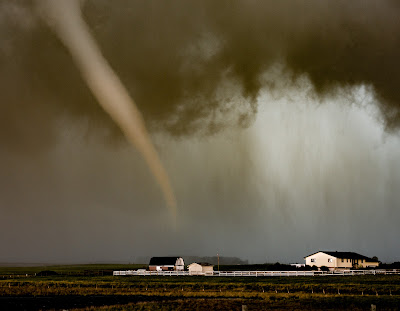
1. May 30-31 Thunderstorm Madness

Ample moisture following a wet spring and powerful upper disturbance from the southwest led to several rounds of intense thunderstorms in southern Alberta between May 30-31st.
First, I observed intense cloud-to-ground lightning in the Banff area during the evening, which lit up the surrounding snowy mountainsides in a rather exciting spectacle. I then headed back toward Calgary, when intense lightning began dropping all around Cochrane during the late evening. We went home and waited for the overnight round, which brought hundreds of lightning strikes to areas south of Calgary. The storm then rolled into downtown Calgary, where I captured a strike hitting the Calgary Tower at about 330AM. I was very excited about this, but decided I should probably try to get a couple of hours of sleep ahead of another big chase day.
About 12 hours later, we documented a tornado at close range southeast of Irricana. Darren and I could see flash condensation whirling over the ground about the base of the condensed funnel, and could hear the tornado as well. It crossed the road about 50 yards in front of me, before going out across a lake as it began to rope out.
Bonus:
And for a moment of wildlife magic, I witnessed a Snowy Owl hork up a pellet east of Calgary in late November. It had consumed several meadow voles, and I know this because I went back the next day to get the pellet intent on dissecting it. It wasn't the first time I saw an owl regurgitate in front of me, either!


No comments:
Post a Comment