Event:
On June 5, 2021, a visually-striking tornado with "Lawnmower Man 2017" vibes occurred just south of Blackie, Alberta, between 1956-2007Z. A damage survey done on behalf of the Northern Tornadoes Project resulted in an EF0 rating, with no observed damage occurring as a result of the tornado itself.
Here is a sequence of varying life stages of the tornado as seen from just to the east.
A large tree limb failed on an isolated tree in the center of the only property impacted, along with two tipped grain bins 2 miles to the south, but the isolated nature of the damage along with its orientation with respect to the WNW winds observed with the storm reveal these occurred as a result of strong thunderstorm outflow.
 |
| Estimated track length 3.5km; track width 250m |
 |
| Single, large tree limb failure |
 |
| A pair of empty bins tipped in the direction of outflow |
In addition to the tornado near Blackie, another weak supercell tornado occurred NE of Longview at 1910Z.
 |
| A faint dust tube can be seen over grassy rangeland to our SW. |
Numerous other vortices occurred this day - a few of which were investigated as potential tornadoes. Two particularly large and long-lived gustnadoes occurred just south and southeast of High River, along with a large, tall likely dust devil near Eltham. All of these vortices occurred along or near a strong wind-shift line, where dry ground and dusty fields provided numerous lithometeors as tracers for easy viewing of any spinups - and likely aided by steep low level lapse rates and ample low level vorticity.
 |
| Likely dust devil near Eltham, viewed from 20km NW |
 |
| Gustnado SW of Frank Lake |
 |
| Parent supercell prior to Blackie tornado |
The parent storm would go on to become a long-track, albeit outflow dominant storm that moved east along the north side of the boundary toward the Saskatchewan border, bringing large hail at times, as well as damaging winds - especially in the Brooks area. Visibility was reduced by blowing dust - especially to the south of the boundary in the drier air, where the cold pool propagated eastward more quickly over dry ground in the downslope flow. I tracked it as far as Atlee, where an impressive hail swath and more large gustnadoes and mini haboobs occurred.
 |
| Large gustnado east of Jenner |
 |
| Hail swath near Atlee |
Meteorological Background Environment:
The parent storm that would go on to produce a tornado was the result of a recent merger between two supercell storms to the W/NW of the area that initiated along the foothills - the southernmost of which produced the initial tornado near Longview.
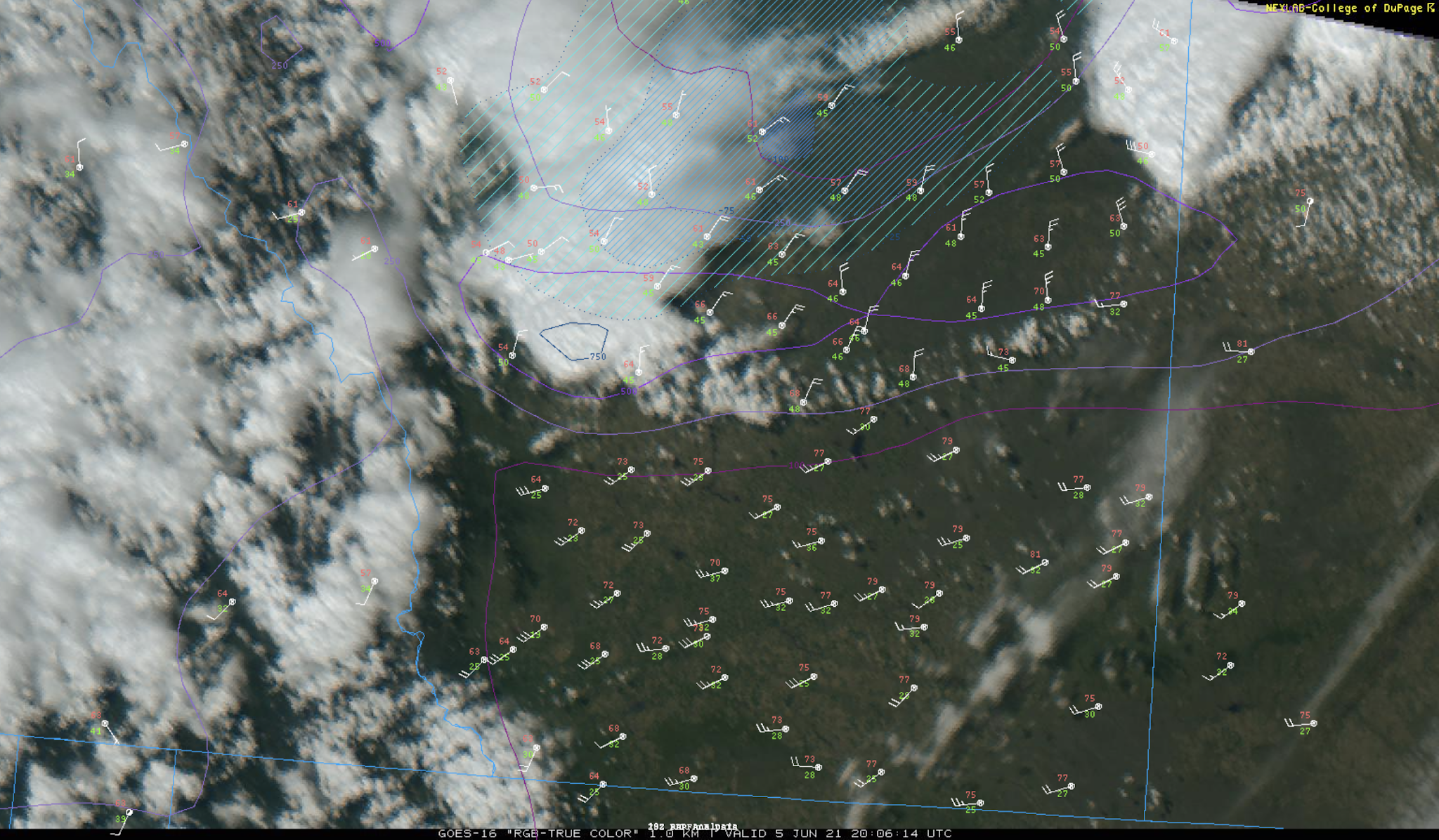
A QS front was draped from west to east across southern Alberta, on the cool, cyclonic shear side of a ~60 knot 500mb jet streak. To the north of the boundary, cool, moist upslope NE flow resulted in vigorous thunderstorm development along the terrain west of Calgary around midday. Moreover, morning thunderstorms in central Alberta were likely reinforcing the boundary on the north side with initially stable, rain-cooled air. Surface observations revealed moderate, ~15 knot NE flow north of boundary, with dewpoints in the 7-10C range. To the south, 20-30 knot SW flow was occurring along with dewpoints near -4C (likely aided by dry soil conditions in southern AB), resulting in a fairly intense and sharp wind shift line and dewpoint gradient. Radar imagery reveals that the low level thermodynamic profile was likely destabilizing in the cool air closer to the boundary on the north side (seen as a reduction in ground clutter), where stratus had retreated and insolation was stronger. RAP mesoanalyses indicated a bullseye of CAPE values on the order of 750J/kg in the near-storm environment.
Along with the mid-level speed maximum, downward momentum transfer was likely occurring in the deeper CBL to the south of the boundary as a result of strong cross-barrier flow, as the boundary was seen to push northwards near the time of the Blackie tornado.
 |
| Visible satellite with surface obs and RAP analysis of CAPE/CIN |
 |
| Water vapour with 500mb RAP analysis |
 |
| CASSM reflectivity/velocity after tornado has begun |
 |
| NAM3 forecast thermo/kinematic environment in CAPE bullseye at 19Z |
For timelapse video that I shot of tornadogenesis and maturity, click here.
Given the background environment and some visual characteristics, it appears likely this tornado occurred closer to the supercell end of the supercell-nonsupercell tornadogenesis spectrum. However, it is interesting to consider the potential of some non-supercell processes as well given the presence of rich low-level vertical vorticity along the boundary, along with steep low level lapse rates - especially along the south side of the boundary. This was also evidenced by the numerous dust devils and gustnadoes present in the area. Moreover, it is unknown to what extent a recent merger may have played a role in the overall process. Regardless, new updraft development with the parent storm was seen to propagate rapidly eastward along the boundary just prior to and during the tornado. Having driven past the location where the tornado spun up a couple of minutes earlier, I recall how striking it was that strong easterlies were occurring at my location (even lofting dust), while strong westerlies were occurring in the fields to the south, resulting in strong local horizontal shear.
It was a relief that the tornado itself didn't cause any damage or injuries, given that it spun up right in someone's property and crossed a major secondary highway.