Friday 31 December 2021

Top 10 Events of 2021

 10. Sunrises and Sunsets


While great sunrises and sunsets can happen anywhere, the Canadian Prairies seem to have a high frequency of truly spectacular events in a given year. This is particularly true in the Chinook Country of southwestern Alberta. Whether it's a morning Chinook Arch with illuminated tendrils of virga, the upwind edge of a Chinook Arch at sunset, or evening mammatus after a storm, there's no shortage of banger events treating delighted locals. 

All scenes above were shot on my smartphone in 2021.


9. Southern Alberta Grassfire, then Dust Storm 


On March 28th, a strong downslope wind event brought wind gusts in excess of 100km/h along the Highway 2 corridor south of Calgary, igniting a grassfire that would rapidly burn a swath of dry farmland as well as several structures east of Claresholm. 


Burn scar and dust storm seen from space. Satellite image courtesy Sentinel

Torched fenceposts amid blowing topsoil

On April 1, another downslope wind event created a significant local dust storm within and east of the burn scar, liberating tonnes of topsoil. 

On April 17, we observed numerous dust devils over the locally-low albedo surface of the burn scar during the warm, dry, and windless afternoon. Nearby, we observed an absolutely massive dust devil that formed on an alkali lake bed. 


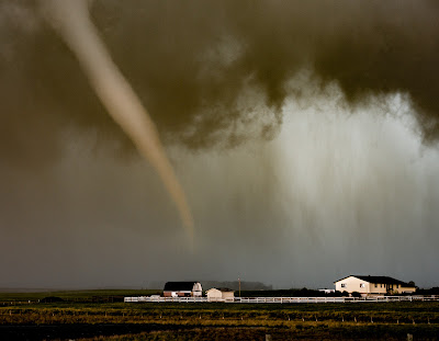
8. High River Area Tornadoes


Tornadogenesis

Maturity

On June 5th, we observed a pair of tornadoes south of Calgary. The first occurred near Longview, and the second, pictured above, occurred just southwest of Blackie. The latter had "Lawnmower Man" vibes, as indeed, it developed in a similar environment - but thankfully resulted in no damage or injuries despite crossing over a major secondary highway. It's always encouraging to nail your storm chasing target a day or two in advance.

A number of other large gustnadoes and dust devils occurred in the area as well, with steep low level lapse rates owing to a dry surface, along with the presence of a wind shift boundary in the area. I wrote more about this event here.


7. Amazing Aurora Event


During the early morning of November 4th, an incredible, long duration Aurora event occurred, bringing dazzling pillars of green, purple and red to the skies within the Auroral Oval. What was really notable in the Calgary area was the dancing corona overhead, as the lights flickered and swayed vigorously for several hours after midnight. 

Other really good Aurora events occurred on March 20th and April 16th. As we head into the next solar maximum that peaks in July 2025, there will undoubtedly be more stunning displays ahead. 


6. Cold Weather Experiments


Without fail, my best-performing content in a given year is always related to the extreme cold, and the shenanigans we get up to in it. 

This year, besides the classic hot water toss, I tried a number of other cold weather experiments, including:

- A banana hammer

- A frozen clothes percussion ensemble

- More frozen foods

- A frozen towel airplane

- A frozen towel toboggan

Additionally, I opportunistically shot video of me karate kicking rime ice off of chainlink fences and ball diamonds in southeast Calgary on January 24th. 


5. Knocked Over by Wind


On January 19th, I climbed up to the summit of Nakiska Ridgetop for a second time to document the wind. I had been practicing my pattern recognition to see what kind weather conditions lead to maximum wind gusts, so  I went out when I figured I had found my weather window. As I was up there, I encountered a 193km/h gust - far stronger than the previous year's 124km/h gust. 

I learned that I couldn't stand when gusts exceeded about 170-180km/h, and learned that I'll need knee and elbow pads next time for getting knocked down onto the hard scree. I had to crawl a fair ways down the upper ridge because it was simply too hard to stand. That's one way to feel humbled by nature and get the adrenaline dumping!


4. Transport Truck Tips Over


On January 12th, a strong downslope wind event in southern Alberta resulted in a number of transport trucks tipping over along highways 2 and 22 south of Calgary in typical fashion. These roadways run perpendicular to the terrain, and thus, the crosswinds that roar down the slopes of the front range and foothills. Any trucker caught off guard with a light load owing to a sudden gust - especially when banking away from the wind in the southbound lanes - can find their world suddenly going sideways. 

Thankfully, the trucker involved here was unharmed, but that's not always the case. 


3. All-time Record Heat in Lytton, BC


50C on the TWN vehicle thermometer


On June 29th, Lytton broke Canada's all-time national high temperature record for the third day straight, at 49.6C. The heat was stifling, making it hard to work outside for long, and causing my camera gear to rapidly overheat. The air smelled strongly of cooked sagebrush and juniper, and your feet would burn through the soles of your shoes on the hot pavement. Lytton is often BC's hotspot, so that felt like the safe place to target for experiencing maximum heat. 

Initially, the mood was lighthearted, as I was attempting to fry and melt things on a cast-iron pan on the street in the scorching heat. Little did I know that the next day the village would be gone. I wrote at length about the experience here


2. BC Firestorms


Pyrocumulonimbus cloud near Savona on June 29th


The same day that Lytton broke the all-time record high, a number of large, human-caused wildfires rapidly took off. Heading back toward Kamloops, I saw a gigantic pyrocumulonimbus cloud blowing up over the Sparks Lake fire near Savona. 

The following day (June 30th), the firestorm raged on, with numerous, powerful cloud to ground lightning strikes being generated by the plume several kilometres north of the fire, which sparked more wildfires. There's something about documenting wildfires that is uniquely intense and stressful. Here are some more visuals from the area on the day that Lytton burned down nearby, and a more in-depth look at the event.  


1. The Sun is Blotted Out of the Afternoon Sky


BC's fire season was just relentless, so I found myself back in the interior providing live coverage in mid-August after the whole city of Vernon was put on evacuation alert ahead of the nearby White Rock Lake fire. It was more personal for me this time as well, as I have family in the city. 

On August 14th, the skies in Vernon turned an apocalyptic orange, as I walked the streets of downtown. 

On August 15th, the thick, combined plumes of the White Rock Lake and Tremont Creek wildfires blotted out the afternoon sun along Highway 97 northwest of Vernon. It was here that I shot the most intense Facebook Live of my life to date. 


Darkness at 430PM


More:


2021 was really hard for a lot of folks - and not just because of the weather. It has been a very challenging year for me personally, and I have been taking the time to self-care and get the help I need. 

On a brighter note, I was able to document 8 out of Alberta's 12 species of owl in 2021. I drove thousands of kilometres, and didn't manage many very good photos, but my love of these elusive creatures grows more every year. I am excited to see how I'll do in 2022!


Owls of 2021:

- Snowy Owl

- Great Grey Owl

- Great Horned Owl

- Northern Pygmy Owl

- Northern Saw Whet Owl

- Boreal Owl* (very rare)

- Short-eared Owl (favourite)

- Northern Hawk Owl


Missing:

- Barred Owl

- Long-eared Owl

- Eastern Screech Owl (rare)

- Burrowing Owl* (very rare) 


Robert, the Downy Woodpecker

I've also had up to eight species of bird eat from my hand in Calgary this fall. These include Black-capped Chickadees, Boreal Chickadees, Mountain Chickadees, Red-breasted Nuthatches, White-breasted Nuthatches, and Rock Pigeons. I am most excited about the Downy Woodpeckers and Black-billed Magpies, though! 


Thursday 30 December 2021

Top 10 Events of 2020

 10. Plate Stack Lenticulars


On December 15, an incredible lenticular stack occurred atop a standing wave east of Centre Peak in southwest Alberta. Wintertime along the foothills of Alberta can be an interesting time for watching clouds associated with Chinooks and downslope windstorms. 

Earlier in the year, timelapse imagery revealed the impressive motion of a violently tumbling rotor cloud, as snow was being lofted off front range peaks by winds gusting over 160km/h. 


Screengrab of above linked video. 


9. Central Alberta Ice Jams


Ice Jam on the Little Red Deer River, west of Bowden


Very cold conditions through late winter led to very thick ice coverage on rivers across Alberta. Then, a sudden spring thaw led to rapid melt of snow cover that flowed into rivers  as runoff, leading to rapid breakup of the ice. This ice then jammed up near prominent bends in the rivers, at times letting loose and bulldozing over adjacent banks. Major flooding occurred in the city of Fort McMurray, and the River Creek RV Park near Stettler was destroyed by thick river ice. 


8. Alberta Wild Ice


The above bubbles form at Abraham Lake every year, resulting from decaying organic matter on the bottom of the lake that give off methane bubbles that become frozen into the ice. Alberta has plenty of wild ice, but this is some of the most stunning. 

High in the Alberta alpine, retreating ice sheets also lead to some caves near the toe of the glaciers. These areas can be difficult and technical to access, but they're truly stunning. 


7. Southwest Alberta Windstorm


I went up to document the winds on Nakiska Ridgetop for my first time on January 31st, where one of the windiest ECCC weather stations in the country exists. I only observed a gust of 124km/h this time (I say "only" because 200km/h+ gusts can occur at times), but it was still an intense experience, as daylight waned in the huge, inhospitable mountain environment. 

After descending the mountain and receiving a flurry of anxious texts from friends and family who were  waiting to hear from me, I drove south of Calgary late that evening with my friend Darren, where we documented severe winds into the early morning hours of February 1. We had 140km/h gusts near Granum, with trucks tipping over along the typical stretch of Highway 2. Turns out I didn't need to climb a mountain to experience high winds!


6. June 13th Monster Thunderstorms


Supercell near Vauxall


June 12-13th brought back-to-back days of intense thunderstorms to southern Alberta, as a large scale negatively-tilted trough pivoted out of the western US. An earlier, similar setup also occurred a couple of weeks earlier that also brought severe weather. It had been a wet spring, so there was plenty of moisture available for severe storms. 

On June 13th, we watched as several attempts at severe storms popped near the US border south of Lethbridge, until a dominant storm tracked NNE out of the Montana foothills and just west of Highway 36 through southern Alberta, into rich low level moisture throughout the evening hours. It produced a tornado south of Taber (only a single weak one, somewhat surprisingly), softball-sized hail NW of Brooks, and intense lightning. Meanwhile, that evening, the costliest hailstorm in Canadian history would pummel northeast Calgary with wind-driven tennis ball-sized hail, resulting in losses of $1.2B. 

Video of the aftermath in Calgary here and here.


Photogenic thunderstorm near Nanton on June 12th. 


5. Stunning Fall Colours


The period from late September through the second week of October brought one of the best displays of fall colours to southern Alberta in recent memory. A wet summer had given way to long, clear, and cool nights in early fall that would lead to vibrant yellows in larch and aspen poplar around southwestern Alberta. 

It was particularly wonderful in the Rockies, with numerous clear mornings over our famous glass-like lakes


4. Mountain Thunderstorm


It is a rare treat to see a sculpted thunderstorm in the mountains, but that's what we saw on the evening of July 31st. A strong, slow-moving thunderstorm clung to the front range of the Rockies west of  Calgary, sinking south-eastward throughout the evening. When it reached some locally-enhanced storm-relative inflow at Morley Flats, the storm intensified and dropped tennis ball-sized hail along the Trans-Canada Highway. 

We dropped south on Highway 40, and watched the wonderfully-illuminated western edge of the storm from behind, as clear skies to the west helped to prolong the sunset. We even saw a grizzly foraging in the ditch along the road. A memorable evening with Darren and Poi Yee, indeed!


3. Calgary Supercell


On July 23rd, we hung back near Calgary based on a favourable real-time environment for severe  weather - despite the more well-advertised target to the north, which was struggling with cloud cover issues. Severe storms erupted just west of the city in the early afternoon, with the dominant storm tracking right over the city. A tornado warning was issued, as we saw a large funnel just west of Signal Hill, which brought some intense moments as we observed the storm from the side of a busy Glenmore Trail in the southwest. 

After a frustrating escape through the city, we watched as the storm churned with impressive rotation over Calgary and eastward across southern Alberta through the evening, along with two other supercells. 


2. Frozen Pants Make the Tonight Show


In my second winter of doing cold weather experiments, we tried to freeze some clothes to play around with, among other things. We proceeded to smack the clothes on a brick wall and throw them around like frisbees, all while filming it. A couple of mornings later we found out it made it onto the Tonight Show. I can now say I've made Jimmy Fallon laugh!


1. May 30-31 Thunderstorm Madness


Ample moisture following a wet spring and powerful upper disturbance from the southwest led to several rounds of intense thunderstorms in southern Alberta between May 30-31st. 

First, I observed intense cloud-to-ground lightning in the Banff area during the evening, which lit up the surrounding snowy mountainsides in a rather exciting spectacle. I then headed back toward Calgary, when intense lightning began dropping all around Cochrane during the late evening. We went home and waited for the overnight round, which brought hundreds of lightning strikes to areas south of Calgary. The storm then rolled into downtown Calgary, where I captured a strike hitting the Calgary Tower at about 330AM. I was very excited about this, but decided I should probably try to get a couple of hours of sleep ahead of another big chase day. 

About 12 hours later, we documented a tornado at close range southeast of Irricana. Darren and I could see flash condensation whirling over the ground about the base of the condensed funnel, and could hear the tornado as well. It crossed the road about 50 yards in front of me, before going out across a lake as it  began to rope out. 


Bonus:


And for a moment of wildlife magic, I witnessed a Snowy Owl hork up a pellet east of Calgary in late  November. It had consumed several meadow voles, and I know this because I went back the next day to get the pellet intent on dissecting it. It wasn't the first time I saw an owl regurgitate in front of me, either!


Top 10 Events of 2019

10. McCook, Nebraska Tornado


On May 17th, my chase partner Jo and friends Darren and Poi Yee and I observed a tornado just northwest of McCook, Nebraska. It was probably the most photogenic of all the tornadoes we observed on our Tornado Alley adventures in 2019. Unfortunately, it caused EF2 damage. We missed a later photogenic tornado, opting out of taking area backroads in our rental car. It was nonetheless satisfying seeing a target come to fruition as forecast a couple of days earlier.


9. Waterton Snowstorm


During the last few days of September, a tremendous snowstorm impacted southwestern Alberta, bringing nearly a metre of storm total snow. It made for memorable scenes and live reports! I wrote at length about it here


8. Southern Manitoba Snowstorm


Heavy, wet snow and strong winds wreaked havoc on the power grid around southern Manitoba between October 10-12, along with large numbers of trees still covered in fall foliage that would sustain significant damage to limbs. I never thought I'd see a transmission tower crumple as a result of wind-driven wet snow. I wrote about it here

I had originally intended to cover the storm from the more populous Winnipeg, but got stuck in Portage La Prairie, where the storm was more intense. There, power would go out at my hotel and roads were just barely drivable. During one hit, power flashes were occurring, before the winds - gusting to near 90km/h - would take out my camera


7. Maritimes Winter Storm


I flew out to Halifax in mid-January to meet Chris St. Clair, before heading out to Fredericton together to cover an incoming Nor'Easter that was set to deliver high-impact, mixed wintry weather across the Maritimes. Getting my first taste of live active weather coverage and getting expert advice from a veteran of Canadian weather communication were probably the highlights of the trip. I also learned what storm chips were all about!


6. Birthday Storm Chase in Saskatchewan


On June 27th, we tracked intense thunderstorms through far southwest Saskatchewan. There would also  be photogenic storms in a similar area on the 28th. 

It was truly a quintessential Saskatchewan storm chasing experience. A sculpted shelf cloud roaring over the grasslands, nicely framed by classic foreground of prairie abandonment.


5. Crossfield, Alberta Tornado


On July 14, a brief tornado occurred near Crossfield, Alberta, next to a busy stretch of the QE2 Highway north of Calgary. While not overly photogenic, it was memorable to watch the entire event with friends from building cumuli to gusting out thunderstorm well to the east. Our damage survey revealed EF1 damage, and drone shots of the narrow tornado track through barley fields were pretty cool. I wrote about this event and others here.


4. Extreme Cold in the Eastern Prairies

Winnipeg, with a windchill of -50

Photo by friend Craig Boehm of my first solo live hit.


In late January, I went to Regina to cover my first ever winter storm. It was just a couple of weeks after learning the ropes of live TV with Chris in the Maritimes, so I felt ready. My first solo TV hit actually ended up being for CBC National, after which I learned I prefer live hits to off-airs. 

The extreme cold followed the Saskatchewan blizzard, so I went to Winnipeg to cover that. There I would also try some of my first cold weather experiments


3. Severe Thunderstorm and a Blizzard 


On April 27th, chase partner Darren and I had a wild day in southern Alberta. We started the day on sketchy roads in accumulating snow south of Drumheller. We then moved a little ways southeast, and  documented a severe thunderstorm with hail and a funnel cloud near Brooks. On the way back to Calgary, we encountered blizzard conditions near Strathmore. It was the first day in my life I had been under a severe thunderstorm warning and blizzard warning at the same time. I wrote more about it here.


2. Otherworldly Skies 


On July 23, friends Darren, Poi Yee and I observed a very memorable spectacle near Alder Flats, Alberta. An elevated supercell crept out of the foothills, lit from behind and below by the setting sun. Though it was a fairly quiet scene - save for some gentle thunder and the cattle losing it in front of us - the skies seemed as though they were screaming. The upward motion like a giant vacuum was incredible to witness. Needless to say, I was excited


1. Carmangay Tornado Aftermath


On July 18th, an EF2 tornado impacted a property as it weaved through the Blackspring Ridge wind farm east of Carmangay, Alberta. It would damage the home, and destroy a shop that housed some little Calico kittens. 

The family dog Belle was carried away by the tornado, but within a couple of hours, she came back unhurt (see photo above). As we were documenting the damage, we rescued the remaining kitten that had been missing beneath the rubble, after hearing its cries. 

Tree branches from a tree in the slammed into the house and penetrated into the living room. It reminded me of a similar scene I had seen a few days earlier in Eston, SK, where a 2x6 had impaled a home as a result of an intense downburst. I wrote more about these events here.


2x6 in the wall in Eston, SK.