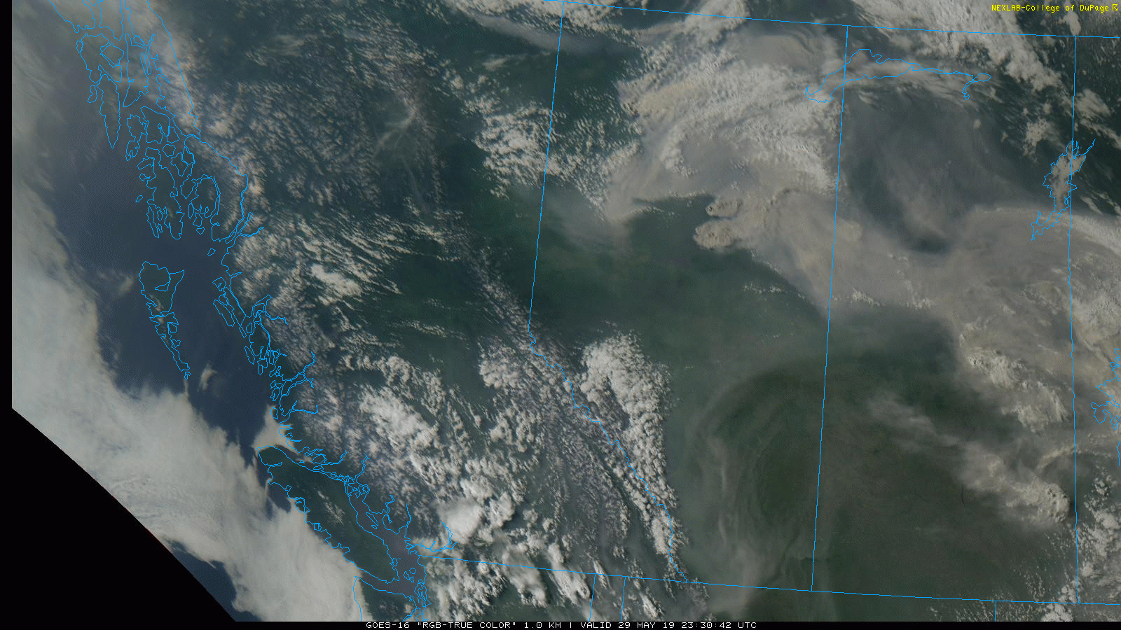
On the weekend of April 27-28, a very potent spring storm system moved across southern Alberta and Saskatchewan, bringing all four seasons of weather. Being north of the PFJ, cooler than average weather was already in situ across western Canada. A potent shortwave would ripple through W/NW flow aloft, bringing the strongest forcing for ascent across the region, resulting in unusually strong dynamics. The mass response resulted in strong winds that worked in combination with heavy snowfall rates to create blizzard conditions Saturday evening and into Sunday morning across SW Saskatchewan. Also of note was locally enhanced precipitation rates in areas where terrain acted to enhance lift - even near gradual rises in the land where there was only 100-200m of difference in elevation over several kilometres. Blizzard warnings were in place across much of the south, with winter storm warnings to the west along the southern foothills including Calgary, and snowfall warnings further northwest. For the 3 severe thunderstorm warnings issued in the SE in the afternoon, they would have also had concurrent blizzard warnings. Cool!
 |
| 500mb analysis at 12Z Saturday reveals the main trough is still back near northern Vancouver Island at this time. |
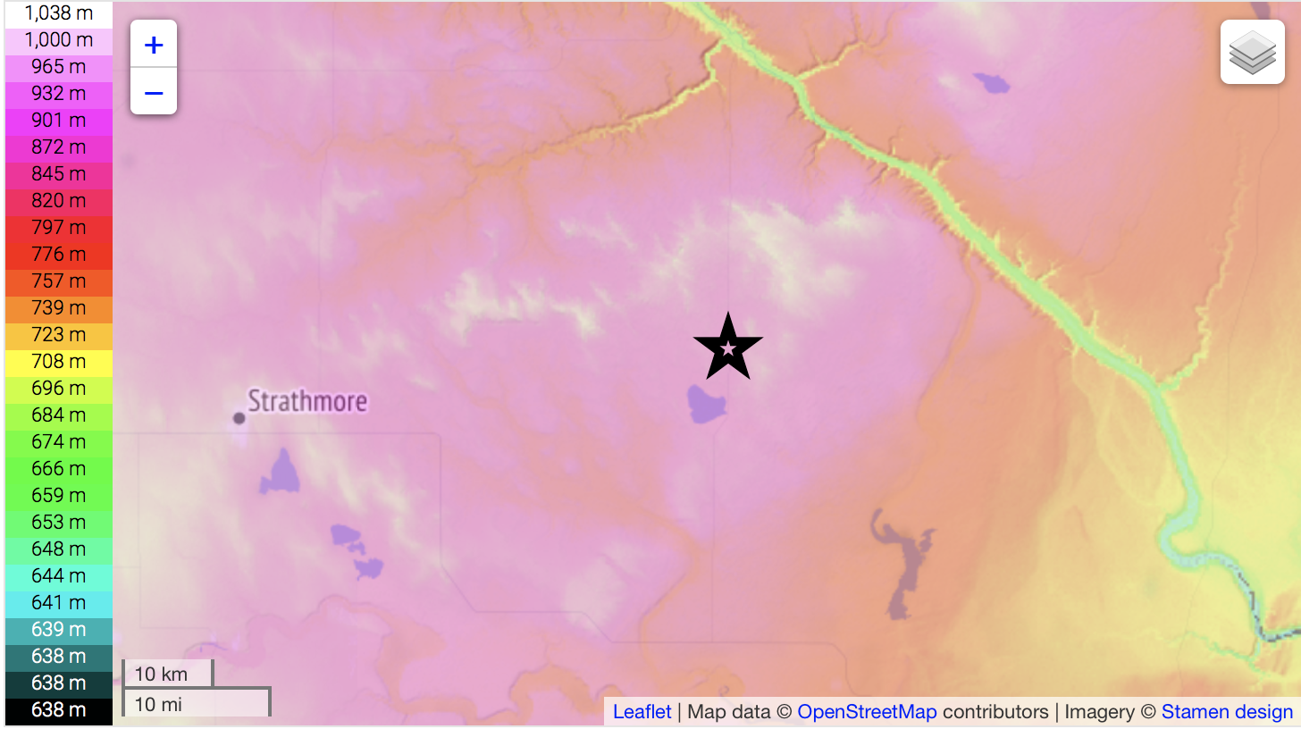
We decided to get a taste for all of it - with the hopes of hearing our first thunder of 2019 in the afternoon. Darren and I left Calgary at 8AM and headed for the nearest snow - which had set up in a near-stationary band NE of the city, which trended NW into central AB, causing havoc on roads there. In Drumheller, it was snowing heavily, but it was very wet. Water was gushing out of the badlands near the hoodoos SE of town. In the valley bottom, the snow was hardly sticking - unlike at ridgetop. After doing a few soggy hits for TV, we headed south on 56 toward HWY 1, and encountered gradually worsening road conditions. Very strong SE flow and enhanced snowfall rates were covering the road with drifts a foot deep in places, and we saw a few vehicles in the ditch while white-knuckling and fish-tailing ourselves. It turns out the worst of it was on the south slope of a W-E trending ridge south of Drumheller, and the ploughs were only going as far north as Hussar. Just north of the town was the worst, but then it rapidly improved as we passed the town. By the time we hit Bassano, there was only a trace of snow on the ground.
 |
| The star is where roads were worst, just north of Hussar. The ridge just north is about 200m higher than the terrain near the Crawling Valley Reservoir about 30km to the SE. |
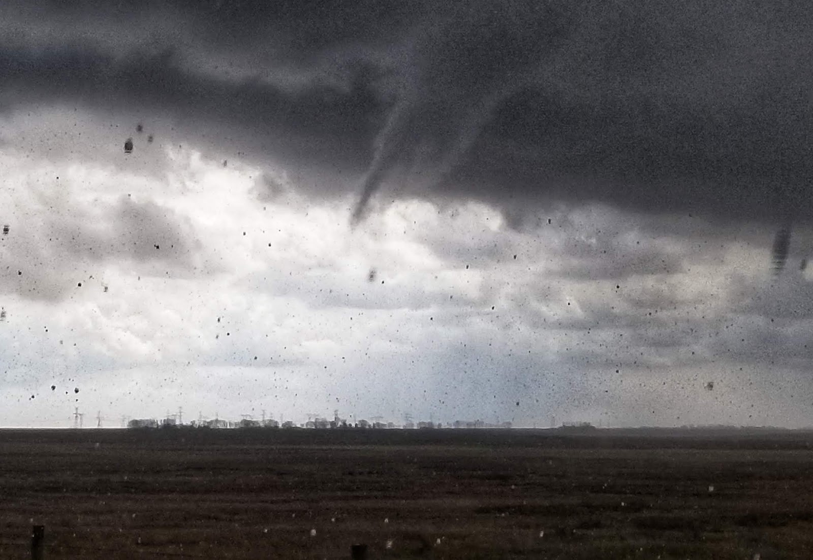
Only 63km SE of the location where the roads were the worst, and not an hour later, we were in patches of sun and had temperatures of 8/4, with no snow anywhere to be seen. Towering CU were billowing up all around and within minutes, we observed our first vivid CG strikes from a developing storm near the 36/1 intersection. These storms had pleasantly low LCLs and were drifting slowly NW, in an environment of locally pooled moisture and rich vorticity near the surface low. This was a promising area to see funnel clouds, and the clear thunderstorm target. Then, less than an hour after nearly sliding into the ditch in deep snow, we witnessed a funnel cloud that lasted a little over a minute, as 12mm hail was falling around us in a rest area where numerous others were pulled over.
 |
| Funnel cloud, which occurred at around 1913Z. |
 |
| 18Z surface obs. Note the clear slot into SW AB. Very cold air aloft began to advect over the narrow moist axis around midday, leading to significant destabilization. 8/4 can get it done in Alberta! |
After the funnel dissipated, we sat in the same location watching the cloud bases for at least another half hour, as hail piled up on the road surface around us (to over 10cm), and slowly increased in size. We reported 17.5mm hail, and shortly after, the storm went severe warned. Cars started sliding into the ditch once again as a result of the hail.
 |
| Hail covers the road on the TCH at the rest stop just west of 36. |
We then went and did a few more TV hits, before having a late lunch in Brooks for a much-appreciated break. Just as we finished a second storm developed south of town, so we intercepted it in Rolling Hills, before heading around the road hole toward Suffield to catch it as it slowly drifted across. Strong E/NE surface flow with still-decent moisture continued feeding the storm and restraining its outflow, with new updraft bases developing on the eastern flanks in cycles. As the bases began to precipitate, lightning activity would ramp up. Almost like clockwork, we observed a sizeable flash of lightning every 20 seconds or so, with many CGs. It was a very good first storm! Eventually, we abandoned it as it fizzled, and headed back NW. Along the way, we crossed the still-melting hail swath from the first storm and found it to be very localized - taking about 40 seconds to transect at highway speed. Then, it was on to the blizzard.
 |
| Video screenshot of a nice CG we caught to our SW. |
First, we were hit by blasting northerly flow behind the cold front somewhere between Bassano and Gleichen, where Darren was observing gusts on the Kestrel of over 30 knots. Some snow was being lofted but the area had very little on the ground, with the heaviest precipitation bands still to the north. As we got heading west into Strathmore on the final stretch, we began to encounter whiteout conditions - as there was much more snow on the ground in the area. The temperature was still 0-1C, so I couldn't imagine how much more snow would drift if colder.
 |
| Also a video screenshot of the blizzard conditions in Strathmore. |
The highway toward Calgary was shut owing to an "80-100 car pile-up" in Chestermere, so we had dinner at BP's under flickering lights as the storm raged outside. We also shot some decent footage in town, before finding a ninja way back with no one else on it all the way to the city, arriving near midnight.
 |
| Our stops for the day. |
The storm would dump 30cm along the central foothills, 35-40cm across far SW Saskatchewan, and possibly more locally along the north slope of the Cypress Hills. Winds would gust in excess of 100km/h across southern Alberta into the overnight, and very cold conditions would follow the system in the days to come. Despite travel woes, the moisture was much appreciated across the region.
It was a truly memorable day for both of us, with exciting driving conditions, two severe warned storms, a funnel cloud, hail, and the worst blizzard I've seen - all in a late April day's work.
 |
| Get a load of this. |
Here is a link to our visuals and a summary of the storm:
https://www.theweathernetwork.com/ca/videos/gallery/revisit-some-of-the-amazing-scenes-of-snow-lightning-and-hail-from-alberta-this-weekend/5802443044001/6030852532001/forecasts
Additional progs:
 |
| The system didn't have excellent moisture availability, but enough was able to pool to lead to probably 500J./kg of MLCAPE along the moist axis. Severe warned storms occurred on our Brooks and Ralston storms, with another one near the Hat. |
 |
| Frigid 700mb temps, and an environment supportive of funnel clouds. |
 |
| Low and mid-level lapse rates were quite steep as a result of surface heating beneath rapid cooling aloft. |
 |
| 850mb winds reveal how strong the dynamics were with this compact little system. |