Sunday, 3 March 2019

Significant Weather Events - Latter Half of 2018

The following will be a recap of some of the more significant weather events I covered since between June and December, 2018, as well as some of the more memorable moments I've had as a video journalist for The Weather Network.

The year featured fewer than normal severe storms, large hail, coverage of the aftermath of North America's most violent tornado in 2018, a heavy snow event in Calgary, truck-toppling winds in southern Alberta, and a beautiful waterspout off the coast of Maui to cap off the year. I also got to try grilled cheese with crickets at the Calgary Stampede, and was given a name from a Blackfoot Elder that translates to "storm chaser".

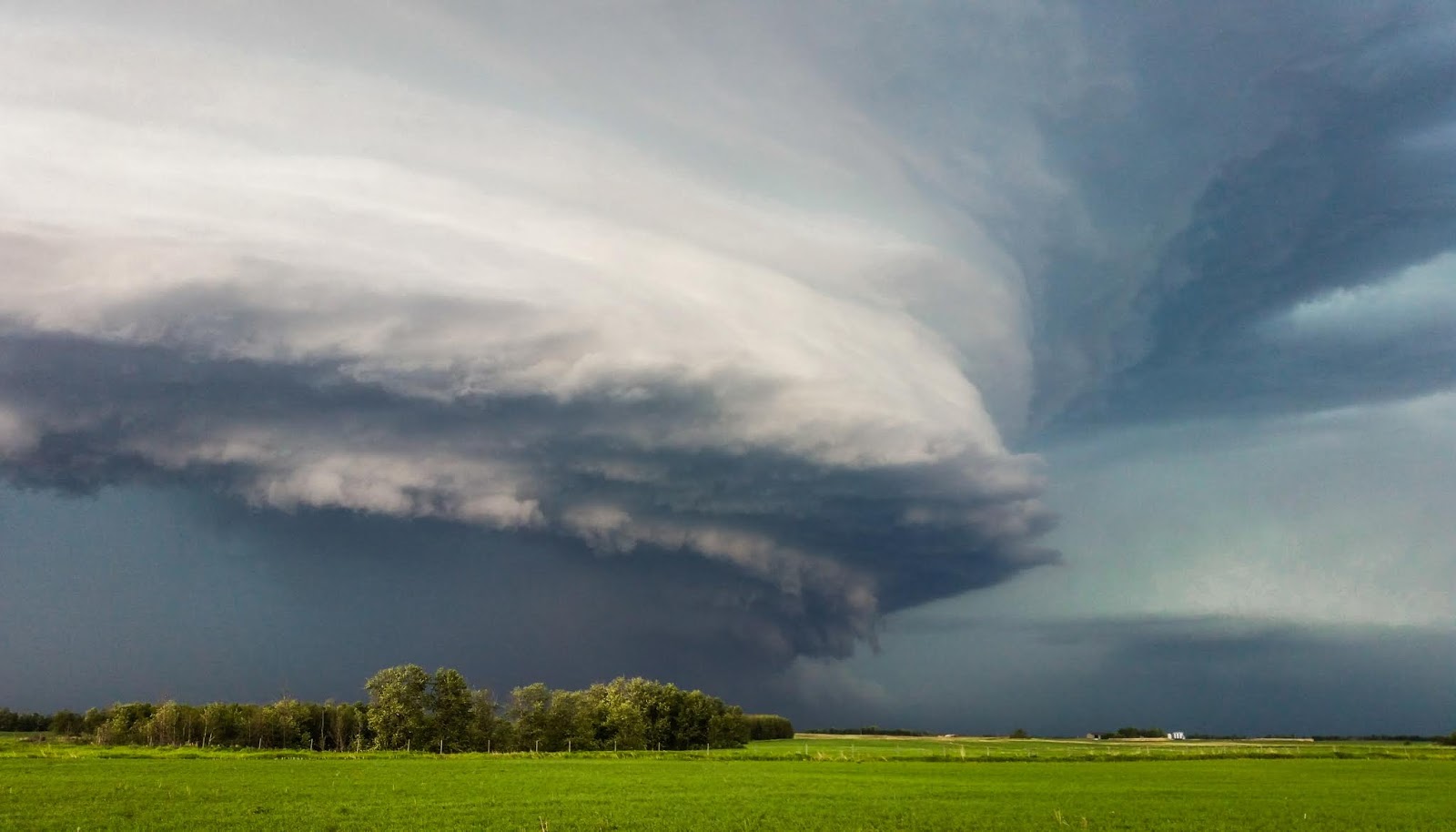
After a rather dull chase trip to the US plains, my next major chase on June 9th in eastern Alberta actually turned out to be my favourite Alberta chase of the season - which is odd, given that it was the first Alberta chase (the foothills seriously underperformed in 2018). Glen Bell and I tracked a storm from near Vegreville that had initially struggled in dry air before crossing a nice moist axis in the boreal transition to the east, blowing up into a wonderfully-sculpted supercell.


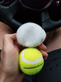
On June 14, Ryan Wunsch and I tracked a beast of a storm that rode the US border near Estevan, Saskatchewan. Having chased a section of the backroads in that area without issue previously, I felt okay with chasing the grid that day. Following a paper map book, we ended up on a road that terminated at a raging river with no bridge, despite it appearing like a legitimate road in the atlas. With the storm bearing down behind us at nearly 70km/h, backtracking meant punching the core of the beast that was chucking baseballs. Needless to say, we got whacked. 


July 10 was the next major prairies chase - also in southern Saskatchewan. Numerous tornadoes were documented that day, though none that I saw. I documented large hail and damaging winds near Val Marie and Mankota. Click here for a look.

MOAR hail.

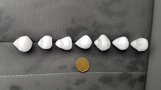
Here is some oddly-shaped hail that fell in July near Dogpound, which formed on conical graupel embryos - apices up.


After August 2, I didn't see another flash of lightning until December 28 in Maui. It was a slow storm year on the prairies, and very smoky once again.

However, covering the Alonsa, Manitoba would prove to be one of the most memorable experiences of the year. I break that down in this post here. Check it out. 

I also visited the Beachwood Estates area of High River to see the community 5 years after the 2013 floods. It was pretty surreal to see what essentially amounted to a ghost town of abandoned luxury homes. Click here for a look inside.

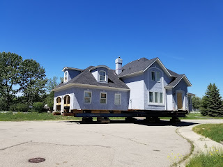
Some homes were propped up on blocks to be moved. Others were destroyed on location.

I visited Waterton Park to see the burn following the previous season's Kenow Mountain wildfire, that threatened destroying the townsite. The new undergrowth was quite stunning, with purple fireweed sprouting up among the black. 


First attempt at shooting the Milky Way, on a summer night at Forgetmenot Pond. There was a grizzly on the other side that kept me slightly anxious in the dark.


My wife and I spent a week on the Big Island of Hawaii in August, and I got to tour the Leilani Estates neighbourhood with a member of the National Guard, just days after the lava river of Fissure 8 turned off. So while I didn't get to see any lava, I did witness the apocalyptic scenes of a neighbourhood covered in lava flows, whose vegetation had wilted in response to sulphur gas. We also visited South Point a day before Hurricane Lane was set to impact the Hawaiian Islands, so we saw some rather large swells pounding the coastline.  

A road vanishes under what was the lava river of Fissure 8.

Unrelated, but also memorable, was being able to sample some strange foods at the Stampede, including prairie oyster balls, cricket grilled cheese, giant squid on a stick, and charcoal ice cream. Click here for a video of the ordeal. 

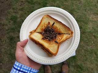
Grilled cheese and crickets. If you close your eyes, they're like crispy onions.

In September, I got to go on a trip to The Weather Network's headquarters for some training. I went a little early so I could do some exploring, and visited Detroit and Point Pelee National Park. While there, I got to witness the migration of the Monarch Butterflies, that were covering leaves in the southernmost trees of mainland Canada by the thousands. Click here to see them!

Meeting my fellow video journalists from around the country!

In fall, I went to the Blackfoot Crossing museum near Bassano, AB, and met a local elder who told me some of the words and phrases in the Blackfoot language used to talk about storms. He also gave me a Blackfoot name, for which I felt highly honoured. Click here to hear his voice.

Calgary also had its snowiest ever day for the month of October on the 2nd, which was also the 7th snowiest day overall, with 32.8cm of snow falling. The storm total was 39cm, which effectively shut down the city for a day, and kicked off what would be the start of a long winter (albeit one that wasn't overly cold until February). Click here for a look at what scenes were like around the city. 

The Canadian Rockies provide many splendid scenes at all times of the year. I enjoyed taking in the golden larches of late September, as well as the opportunity to skate on a recently frozen, glass-like Johnson Lake near Banff. Pure ecstasy. Click here for video of that experience! Also, I checked out a difficult-access cave in Haffner Creek, Kootenay National Park, BC. The delicate stalagmites of ice that formed from slow dripping are quite otherworldly. Click here for a look inside!

Stalactites and stalagmites of ice. 

A strong, downslope wind event toppled trucks in southern Alberta on December 13, and again later in the month (when we were in Hawaii). Between Stavely and Fort Macleod, I think I counted 12 trucks laying the ditch. The strongest winds in this corridor are often unfortunately 100% crosswind. Click here to see a semi shaking in the wind on the side of Highway 2! 

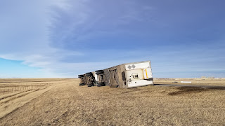
Dec 13 near Claresholm, Alberta

I got to release a weather balloon from the Stony Plain site west of Edmonton in December while doing a story on e-waste. This of course, pleased the weather nerd in me.

Happy weather nerd.


And finally, after going almost the entire year without seeing a tornado, a waterspout formed a couple of miles off the beach of Maui while we were doing a photo shoot. We watched the entire 20-odd minute life cycle, and it was sure exciting!

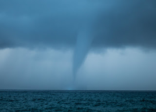
A beefy waterspout harmlessly sips ocean water off Makena Beach,. 


The 2018 Alonsa, Manitoba Tornado

A little before dark on the evening of Friday, August 3rd, a violent tornado carved a swath through aspen forest and cropland before tearing through the Margaret Bruce Beach campground on the western shores of Lake Manitoba, where numerous long weekend campers were impacted. Given a preliminary rating of EF3, the tornado was on the ground for over 20 minutes, with a damage path of up to 800m wide in places. The tornado would soon be upgraded to a low-end EF4 (with winds of nearly 275km/h) as a result of the high-end damage it caused on the property of the single fatality that occurred about 3 kilometres west of the lake. It would end up being the strongest tornado in North America in 2018.

Screenshot of the Alonsa tornado from a cell phone video, courtesy Pamela Sul.  See links below for more footage.


Cell reception was spotty to non-existent near the beach, so the cell phone alerts were largely missed. A few campers at the beach had signal boosters, who were able to alert others nearby that a tornado was approaching. At the last minute, many folks drove west down the only road to and from the beach, which ended up being toward the tornado. Some made it out ahead of the tornado, and some did not. The ones who didn't, along with the rest of the folks at the beach, joined in an impressive effort to shelter in the homes of local residents. Residents of one home had 40 people in their basement, which ended up essentially untouched, while the neighbour's house sustained severe damage.

There were numerous stories of survival that bordered on the miraculous (see links below). Given a scene that was eerily reminiscent of Alberta's Pine Lake tornado in 2000, it very easily could have turned out a lot worse.

Seeing the damage firsthand, and also experiencing the smell of raw, torn up Earth, was a little overwhelming. I had the privilege of speaking with many of the survivors, hearing their harrowing stories, and in many cases being able to tell them. I also got to hear an audio recording of the tornado ripping a cabin off its foundation, with 14 frightened people hiding in the basement. A trailer crashed into the centre of the basement, and a family dog went missing as the tornado passed. To hear the recording alongside the family who struggled to relive the moment as it played was chilling. I will never forget that.

Below, I share links to some of the stories and footage that came of this tornado, along with photographs of the destruction. 

Click here for an interview with Les Brown on his step-father Jack Furrie, 77, who was killed on his property. Also, from a damage survey specialist, who explains the upgrade to EF4.

Click here for stories of campers at the beach who tried to flee the tornado.

Click here for more stories of survival, and the lack of cell reception.

Click here for the story of the family who hid 40 people in their basement, and of their neighbours, who were injured.

Click here to hear about some of the seemingly miraculous occurrences at the Cabak residence.

Click here for amazing footage of the restroom building that was ripped off its foundation, leaving most toilets behind in tact.

Click here for footage of the tornado, as well as other incredible scenes of damage. 

Satellite imagery of the tornado damage scar

Trailers in general are a bad place to be with a tornado approaching.

Several vehicles and hundreds of hay bales were tossed into adjacent Lake Manitoba. Debris would wash ashore for days following the tornado. 

A tractor and baler weighing several tons was picked up and tossed next to the cabin where 14 people survived, despite the cabin being lifted off. 

This is the cabin where 14 people took shelter, in the NW corner by the hot water tank.  After the cabin came off, the cinder block wall on the south side collapsed inward, followed by a trailer landing in the basement, along with other debris. No one was hurt. 

Denuded trees are also a sign of a violent tornado.

Here is the campground restroom. 3 of 4 toilets still intact, despite the building being lifted off and dumped to the east. 

The foundation of Jack Furrie's home. While his bed sheets were in uprooted trees on the property, his mattress was found   nearly a kilometre to the northeast. While he didn't have a basement, there was a shallow root cellar. It is uncertain where he was when the tornado hit, but the winds were so violent here that he would have likely been in peril anywhere in his yard.

Mature trees ripped clean out of the ground a few metres east of the foundation of Furrie's home.

Ground scouring over his garden unearthed potatoes. 

Furrie's dog Brandy was still searching for him several days after the tornado 😢. 

A photo of Furrie's property several years before the tornado.

An aerial photo several days after the tornado of the same scene as above.  It is clear Furrie's home took a direct hit, based on its location in the centre of the damage swath as indicated by the aspen forest. 


Calgary Airport Weather Stations

Recently, I had the chance to visit a weather observer at CYYC, who gave me the lowdown on how things work there. First, the data that is used by MSC's and others' public products is sourced from the Nav Canada contracted station "Calgary Intl A". There is also a second automatic site taking observations that is operated by ECCC, which is the climate site "Calgary Int'l CS". The latter site's instruments actually exist a stone's throw from the weather observers' station, while the observer's actual instruments exist 2km SW of their location, feeding back information about temperature, humidity, and windspeed. A distance of 2km is enough to lead to a slight difference in observed values at times, which we have seen on occasion between the two stations. The other two official stations nearby are those near Canada Olympic Park and at Springbank Airport (which is an auto station as well for some reason, despite being one of Canada's busiest VFR airports).

Google Earth image of Calgary International Airport, and location of weather stations

The observer takes hourly observations of sky conditions and visibility (or more frequently during changeable and significant weather), as well as measurements of precipitation when applicable. The observer's site has a staircase that goes to the roof of the trailer for a clear, 360 degree view of the sky and surrounding horizon. North of the cabin exists a level plot atop which the ceilometer sits (for determining cloud base height/vertical visibility), as well as a rain gauge, a de-commissioned tipping bucket rain gauge, a snow gauge (inside an inverted bell, used for measuring liquid equivalent of snow every 6 hours if applicable), and a weaver snow board (which is a white wooden board used with a wooden ruler to take hourly snow totals, being reported as cumulative every hour that at least a centimetre falls for 6 hour periods, before being dusted off to start again). 

The barometer is inside the observer's cabin, with those values (as well as those of the temperature, humidity, and wind speed) being electronically fed into the system. The values of the ceilometer, sky condition, visibility, and precipitation are manually input by the observer. 

Looking north from the observation deck at the on-site instruments

Observer's trailer and observation deck

A cold, lonely chair on the roof

Barometer showing station pressure inside the cabin

The large copper cylinder sits inside the snow gauge bell collecting snow, before being melted down and poured into a beaker via a funnel

The weaver snow board

A closer look at the snow gauge 

The ECCC-MSC climate station across the road from the observer's cabin


Saturday, 2 March 2019

Spring Outlook 2019

February

Winter 2018/19 started out quite mild. In fact, for a while I was beginning to think that we might not even dip to -20C during the cold season for the first time since records began, as we had escaped those values through November, December, and even January - with weak El Nino conditions being forecast to develop. We even saw an explosion in the tick population during mid-winter, which is quite unusual for the area.

However, come February 1st, it was like a switch was flipped, and we went from anomalously mild conditions to anomalous cold. In fact, February 2019 turned out to be the 4th coldest February in Calgary since records began (1885), after 1904, 1887, and the coldest ever, in 1936. The mean temperature for the month was -18.2C, compared with an average monthly mean temperature of -5.4C. This is in stark contrast to the recent and memorable February of 2016, during a strong El Nino, when the monthly average was 1.4C - the second warmest February on record in Calgary!

Highly anomalous cold existed in the western Canadian Prairies and northern US high plains during February. Image courtesy Weatherbell. 

Every day during the month featured below average temperatures.

A sudden stratospheric warming event took place around New Years, which resulted in the Polar Vortex splitting into two daughter vortices - one of which camped out over northern Hudson Bay for several weeks, sending wave after wave of extreme cold across the Canadian Prairies. Edmonton had an extreme cold warning for 11 consecutive days during the first half of February, and one of Calgary's two weather stations at CYYC failed to rise above freezing the entire month.

The ECCC climate station at Calgary International Airport (not the Nav Canada station, whose data is used publicly) reached -0.4C on Feb 22. Image courtesy ECCC's historical climate data site. 

Going Forward

It seems the current cold in early March across the prairies will be the last extended period of extreme cold of the cold season, as a large-scale pattern change is expected mid-month. Current -EPO conditions will abate in the coming days, as a blocking high over the Beaufort Sea breaks down. Moreover, as deep convection continues to move east across the Indian Ocean, we will likely maintain phase 3 of the MJO for several days which generally teleconnects to continued cool conditions across the prairies. By mid-month, we begin to see signs of neutral and even +PNA conditions, yielding much longed-for upper ridging over western North America, at which time we may see a period of above seasonal values across western Canada between the second and fourth weeks of March. This could yield rapid snowmelt and the possibility of at least minor overland flooding across parts of the prairies, in areas where snowpack is more substantial. Meanwhile, a weak El Nino is ongoing, and has a 55% chance of continuing through the rest of spring according to NCEP. This signal should further yield dry conditions with above seasonal temperatures - especially over the western prairies. Ongoing drought conditions in places and the potential for seasonal wildfires in May throughout the boreal forest are likely to be considerations. 

EPS Ensemble forecasts hinting at +PNA conditions developing during mid-month. Image courtesy weathermodels.com

Weak El Nino conditions could persist into early summer. Image courtesy IRI/CPC. 

The Canadian Drought Monitor reveals that local areas of severe drought have developed across parts of the prairies, with local D2 (severe drought) conditions in far NW Alberta and along the southern foothills, in south-central Saskatchewan, and in the extreme southern Red River Valley of Manitoba. Apparently there is even a pocket of D3 conditions near Fort Vermilion. These are likely the cumulative result of the past two relatively hot and dry growing seasons across much of the prairies. A below-normal snowpack also exists across parts of south-central Alberta. However, winter snowpack plays much less of a role in the development of drought than does a lack of growing season precipitation - since drought conditions are particularly sensitive to the amount of rain that falls in the summer. This is both due to the fact that the ground is frozen in winter, preventing absorption of water, and that over two thirds of annual prairie precipitation falls during the spring and summer - with a large proportion of that resulting from thunderstorms. Dry ground also helps with getting crops planted quicker and more efficiently. We just need that June monsoon to come!

Image from the Canadian Drought Monitor.

Image courtesy ACIS, revealing current snowpack relative to the long-term normal over stubble.

The extreme cold across the eastern prairies, combined with recent heavy snows across southern Manitoba and parts of North Dakota have led to an increased flood risk this spring. A deeply frozen ground and potential rapid warming trend later in March could lead to significant runoff and overland flooding - especially along the Red River Valley south of Winnipeg. Ice jams will also pose a somewhat greater threat this spring owing to the thicker ice that has formed in the extreme cold. The area is accustomed to dealing with spring flood risks, with only minor flooding expected over cropland and some roadways near the Red River. However, the degree of severity of potential flooding will depend on how the month of March transpires - both in terms of additional precipitation, and rapid warming trends following extreme cold. Hopefully, flooding turns out more like 2011 than 2009!  

Snow water equivalent, courtesy NOAA, reveals a sizeable snowpack across parts of central AB/SK, and southern MB.

Meanwhile, the Alberta mountain snowpack is generally normal to above normal north of Highway 1, below normal between Highways 1 and 3, and closer to normal south of Highway 3 to the US border. There is still time for snow to be added to mountain snowpacks, but a dry signal overall through spring reduces the likelihood of this scenario. Nonetheless, both an average summer, or one influenced by El Nino conditions, would tend to yield more normal rains in southern Alberta in June and July, which would both curb developing drought conditions, and ensure a lack of water shortages for southern Alberta's irrigation country. 

Mountain snowpack west and southwest of Calgary is generally running below normal. Image courtesy the Government of Alberta Rivers website. 

...and beyond

For what it's worth, my sense is that following a dry spring, this summer's rainfall and convective activity will trend toward more normal conditions than we saw during the past two years. Weak El Nino conditions may or may not persist into summer, but in either case, more normal precipitation patterns would tend to be expected across southern and central Alberta. In terms of the PDO, slightly cool conditions will likely persist into spring, which also tends to favour cooler and wetter conditions across the prairies - at least in years where more significant negative PDO conditions exist. It is unknown to what extent (if any) this will play on prairie weather this coming warm season, or if the combination of -PDO and weak El Nino conditions will work against each other, reducing their effects. This also goes for tornado season in the US Plains. El Nino conditions often translate to quieter US tornado seasons - however, with no significant large-scale climate patterns expected to dominate into the summer, we could easily see more normal tornado numbers there as well - which might seem like a lot, given the past couple of seasons!

To be taken with a grain of salt at this range, but climate models have been fairly consistent with the transition to wetter conditions in the late spring/early summer in parts of the prairies, including southern Alberta. Image courtesy Tropical Tidbits.

Slightly cooler than average SSTs (-PDO) exist along the west coast of North America. Image courtesy NOAA. 


Wednesday, 17 October 2018

Mountain Peaks Identified on the Horizon West and Southwest of Calgary

**Update**

Check out this link for hi-res versions of these photos, hosted kindly by Larry McNish, aka "Grumpy Old Astronomer":

https://grumpyoldastronomer.com/kylebrittain/

Upon moving to a new apartment with a mountain view (especially to the southwest), I had to take it upon myself to find out what all the peaks were. I have been meaning to do it for a while, having also ascended a number of them. I live 15 floors up in a high-rise in the southeast corner of downtown Calgary, so I don't see any mountains north of Big Sister.

Distances from my location to major landmarks:

Prairie Mountain - 55km
Moose Mountain - 55.5km
Mount Glasgow - 68.5km
Fisher Peak - 72km
Highwood Peak - 75km
Mount Rae - 79km
Closest BC Border - 84km
Mount Lougheed - 84.5km
Mount Livingstone - 103km

Very cool to know that I can barely make out the furthest mountain over 100km away, and that major (3000m+) front range peaks are only 70-80km away from downtown Calgary!

The panoramic shots have been broken into 3 segments, and will be listed north to south.

The northern segment runs from Big Sister in the north, to just north of the Banded Group (where Mounts Burney and Blane are seen through the gap of the Little Elbow river valley):


The middle segment runs from the Banded Group in the north, to Highwood Peak in the south:


The southern segment runs from Lineham Ridge and Junction Mountain in the north to Mount Livingstone in the south:


Summit elevations were mined from the Gaia GPS app. Google Earth, Google Satellite, various photographs, as well as the aforementioned app with topographical maps were used to determine the mountains. Any feedback welcome - especially for additional mountains I may have missed! But this should cover the main peaks between about 194 degrees (Mount Livingstone) and 268 degrees true (Big Sister) relative to my location downtown.

Thursday, 7 December 2017

Rocky Mountain Gap Flow Being Channeled into Calgary - Dec 7, 2017

Calgary weather never fails to be interesting - which is exciting to observe, but tricky to forecast. Especially since most processes that make a significant difference in terms of temperature and wind for instance over small spatial distances, happen on the mesoscale. Before the recent Pineapple Express ate all of our snow, it was interesting to watch the mild temperatures slowly eating away at the edge of a firmly entrenched Arctic air mass, which led to temperature differences approaching 20C across the city at times.

Today, a tremendous, building upper ridge has taken hold along the west coast of the continent, leading to a blocking pattern that will hold for several days to come, bringing us stagnant weather conditions. For us in southern Alberta, this will be a good thing in terms of sunshine and mild temperatures. In the BC interior however, a slack surface pressure gradient means light winds, with persistent valley fog and stratus (as well as air quality issues) beneath the strongly subsiding air, which is destined to take hold for several days in some communities. The only remedy...get up high and/or go skiing!


500mb height anomaly for Thursday Dec 7 at 18Z.
Now, we focus on the task at hand. A strong subsidence inversion has developed (and continues to develop) as a result of large scale sinking air beneath and just downstream of the upper ridge, with the inversion layer occurring a very short distance above the ground. This inversion layer intersects the slope of the Rockies west of Calgary a short distance up, thereby preventing winds from flowing over the tops - especially given the absence of high momentum mid-level flow. However, a strong pressure gradient has developed between air in the mountain valleys (with SLP values approaching 1050mb in the BC interior) and that of the Alberta plain, where there is lower surface pressure. This leads to air having the tendency to squeeze through gaps in the terrain from high to low pressure - otherwise known as gap flows.

12Z NAM3km prog sounding valid at 17Z Dec 7, along the front range of the Rockies west of Calgary. Note the inversion a few hundred metres up.

IR SAT with SLP overlay (since few good hi-res surface analyses exist publicly for this area), at 1630Z Dec 7

12Z Dec 7 500mb analysis, for reference

A relatively large geographical gap in the terrain (or technically the merging of two gaps) exists along the Trans-Canada Highway just east of Exshaw, at the confluence of the Bow and Kananaskis River Valleys. Flow that squeezes through this gap is then channeled by the terrain eastwards toward Calgary along the Bow River Valley. The valley initially trends northeast, and then southeast at Cochrane into the city. Winds are lighter at the surface on the higher terrain above the valley, but breezier within the valley itself - which leads straight into downtown. YYC is situated some distance to the northeast of downtown, outside of the valley, and somewhat blocked from channeled flow owing to Nose Hill just west of the airfield. Where YYC has been consistently been reporting light, sustained winds out of the southwest on the morning of Dec 7, downtown has been getting blasted by a cool, gusty WNW wind.


YYC metars between 15-17Z, on the morning of Dec 7.

My trusty kestrel was consistently reading about 12 gusting 19 knots out of the WNW during the same time frame as the above metars (and all night for that matter! It was noisy!)

17Z surface obs via Wunderground. While some home station readings may be somewhat suspect (like my kestrel), the overall sense is that winds are stronger westerly near Cochrane, turning to more northwesterly as they channel down the valley into Calgary - with lighter winds observed on the surrounding higher terrain.

Even the NAM3km has been consistently and accurately modeling this channeled gap flow. When comparing a topographical map to model output, it is clear that this feature is being resolved at the model's resolution. So while parts of the city may experience light surface winds, areas in lower elevations along the valley in northwest and central parts of the city will likely remain much breezier - a pattern that could very well continue for several days.


Topographical map of the Bow Valley

Note the strong surface pressure gradient along the edge of the Rockies.

Note that the wind maximum follows the shape of the Bow Valley into Calgary. Looks like several more wind maxima/gap flows are being progged further south as well.

In sum, the strong surface pressure gradient that has developed between the BC interior and the Alberta plain, coupled with a strong, low subsidence inversion has favoured the development of gap flows along the front range of the Rockies. The inversion prevents flow over the mountains, so it is instead squeezed through cuts in the terrain - and can be seen channeled through terrain features in a shallow layer over the plains to the east.