Tuesday, 23 February 2021

February Thundersnow in Calgary

 On Monday evening, February 22, thousands of Calgarians were treated to a rare display of wintertime thunder and lightning - all while heavy snow, graupel, and soft hail fell across parts of the city. At least two flashes were detected, with the first occurring over Broadcast Hill in the city's southwest just after 9PM MST, and a second flash at about 920PM over the downtown core. Reports and photo evidence from an area resident confirms the first flash likely hit a TV tower, with the orientation of the lightning bolt indicating an upward flash. In many ways, this was a textbook incidence of self-initiated upward lightning, given the background meteorological environment and presence of tall towers. Let's take a closer look.


Look at Calgary there with its own lightning for miles around. In fact, the next closest lightning was off the Florida coast at about 3900km away!


In terms of the bigger weather picture, a potent shortwave trough moving over the Pacific Northwest would result in the development of a lee cyclone in southern Alberta during the afternoon and evening hours. Significant cooling aloft would accompany the approaching trough and result in destabilization - which, when combined with strong forcing for ascent in the mid-levels of the troposphere, would further serve to steepen mid-level lapse rates and facilitate the ascent of parcels originating in relatively mild and moist Pacific air to their levels of free convection - permitting the development of moist convection. 


500mb RAP analysis, valid at 04Z Feb 23 (9PM local). 500mb temperatures near -32C over Calgary are indicated, with the shortwave trough axis over the Pacific Northwest.
Wind barbs on the station plots indicate the cyclonic wind field associated with the lee low just east of Calgary at 04Z Feb 23. 

Radar trends indicated that snow flurries developing during the mid-evening west of Calgary were becoming more convective in nature, evidenced by intensifying echoes and reflectivity gradients, as a strong vort max that had a history of facilitating the development of lightning in the BC interior a few hours previous moved into southern Alberta. Following the occurrences of lightning in Calgary (which likely occurred as the storm was still in the process of maturing), radar echoes intensified as soft hail 5-10mm in diameter fell across southern sections of the city. 


Radar screen grab from 941PM, a few minutes after the second lightning flash. 


Springbank Airport (CYBW) was more directly impacted by the convective cell than Calgary International Airport (CYYC), so I have selected this site for more representative observations of the storm environment. At 8PM, the temperature was -2C, with a dewpoint temperature of -5C and a slight northwesterly breeze - hardly an environment one would expect to soon be preceding lightning nearby. By 9PM, winds were northwest at 22 gusting to 27 knots, with heavy snow and 1/4 mile visibility as the convective flurries were pushing through. 


According to a study done on the climatology of thundersnow events in the CONUS, mean thundersnow environments were characterized by a stable boundary layer, and a nearly saturated neutral thermal profile above the low level inversion. Thundersnow events in their study did not favour any given time of day, suggesting that dynamic forcing plays a large role in its occurrence, irrespective of diurnal effects. 


Forecast soundings reveal such an environment, with an elevated inflow base, and steep mid level lapse rates. They can also give us a sense of where charge centres within the cloud may occur as a result of the charge separation that results from strong convective updrafts - with the negatively-charged region likely developing more or less centred around parts of the cloud that were about -20C, where mixed phase precipitation including the presence of graupel exist. 


Cloud temperatures were around -20C at about 3km AGL


Now that we've got ample charge separation ongoing associated with these convective, snow-bearing clouds, how do we get lightning? It is an interesting thought to ponder that had this activity not passed over the TV antennae in SW Calgary that top out around 5000 feet ASL, or the towering high-rises of downtown, that this lightning may not have occurred at all. 


It turns out that in these kinds of environments, tall towers such as radio antennae can initiate their own lightning. The tip of the tower is closer to the negatively-charged region (when one exists) within convective clouds than areas on the ground below, which can result in a positively-charged upward leader that brings about an upward lightning flash as negative charge is brought down from the cloud. Therefore, despite the relatively common occurrence of positive lightning in the winter months, it's likely this mechanism resulted in the Calgary lightning flashes having a negative polarity. 


Another very interesting fact is that self-initiated upward lightning becomes more likely when it is windy, since the wind acts to reduce the "corona-produced screening layer" as charge builds up near the tips of tall objects. As can be seen from the observations at CYBW, strong winds were associated with the passage of the convective flurries, which would also result in blowing snow as they passed to the east of Calgary later on. This might also explain how similar conditions led to lightning strikes earlier the same morning in a line of convective flurries that passed over the Wintering Hills wind farm to the east of Calgary, as the churning turbine tips potentially initiated upward lightning when charged convective clouds passed overhead.


Plain Language Summary


- The unstable air necessary for the formation of thunderclouds resulted from a combination of cooling temperatures and rising air in the middle levels of the atmosphere, atop the relatively warmer and more moist Pacific air at the surface. That same rising air also served as the "trigger" for the convective clouds that brought heavy snow, graupel, and soft hail

- Strong updrafts within the convective clouds resulted in the separation of electric charge that is necessary to get lightning discharges. A negative charge likely developed in the clouds some distance above the surface, while the Earth below possessed a positive charge

- Since the tall structures that were hit (TV antennae and high-rise buildings) are closer to the negatively-charged area of the cloud than surrounding areas on the ground, they likely initiated their own lightning. The presence of strong winds atop the towers also made this more possible. 

- Had these convective clouds passed over an area without tall towers, it is possible that no lightning would have occurred at all. Thus, it was a special convergence of factors that led to the thundersnow event in Calgary!

Friday, 6 November 2020

Canadian Prairie Snowstorm of Nov 7-9, 2020

 Meteorology 


A memorable, and perhaps record-breaking winter storm is set to impact much of the prairies this weekend, bringing heavy snow and strong winds that will likely make travel difficult to impossible at times through much of southern Saskatchewan and portions of southern Alberta.

As a large upper low/trough digs into the southwest US throughout the day on Saturday, a broad deformation zone develops from the northern US Rockies through southeastern Alberta northeastwards into the central prairies. Heavy snow will develop along this feature throughout the day on Saturday, with strong northerly winds developing by late day into southern Alberta, enhancing upslope effects in the southern foothills as well as along the north slope of the Cypress Hills, resulting in blowing and drifting snow throughout much of the southern half of the province. 

As a potent shortwave trough with increasing negative tilt begins to lift northeast out of the central and northern US Rockies, a strong area of low pressure departs the mountains of northern Wyoming and reconstitutes itself northeastwards along a barolinic zone through the Dakotas and into Manitoba by late Sunday evening. As isentropic lift increases throughout the day on Sunday poleward of the surface warm frontal zone, ice pellets and freezing rain are likely along an axis stretching from eastern Montana and extreme southeastern Saskatchewan, through southwestern and central Manitoba, and into far northwestern Ontario. Meanwhile, strong cold air advection northwest of the low begins to wrap increasingly cold air into the system, with heavy snow northwest of the low’s track developing from central Montana into southern Saskatchewan, and on into central and northern Manitoba, resulting in a second round of heavy accumulations across parts of the prairies. 

As strong surface pressure rises occur northwest of the low associated with cold air spilling southwards to the east of the Rockies, strong low level winds result from southeastern Alberta through southern Saskatchewan on Sunday – and, when combined with a 50+ knot northeasterly H850 jet resulting in strong wind gusts throughout southern Saskatchewan during the latter half of Sunday as the low reaches peak intensity – whiteout conditions will result in blowing and drifting snow, making travel difficult to impossible over a broad area. 

With a broad area of 30-50cm falling across the region, it is possible that several monthly 24 hour record snow totals could be broken across portions of Saskatchewan – especially where accumulations between both rounds of snow overlap. The snow moves out of the southern prairies on Monday morning, with cold temperatures and wind chills in its wake. 


Friday 18Z NAM prog valid 6PM CST Sunday, Nov 8. 
A potent "Wyoming" low cuts through the heart of the continent.

Impacts


It is highly likely that the greatest impacts will be to travel throughout the weekend, as road closures will become likely across parts of southern Alberta and much of southern Saskatchewan between late day Saturday and early Monday. Visibilities will be reduced to near zero in blizzard conditions, with winds having a strong crosswind component throughout the Trans-Canada Highway corridor west of Regina. Snow ploughs will likely have great difficulty keeping up with clearing off  ever-building snow drifts, as large amounts of snow will be available for transport in amply strong winds. As such, all travel should be avoided across the most heavily-impacted areas of the prairies this weekend. Those who must drive should exercise extreme caution and have an emergency safety kit in their vehicle that is easily accessible.

In addition, within the aforementioned corridor of freezing rain accumulations, ice accretion will likely yield slippery road conditions and perhaps some sporadic power outages in more heavily-affected areas. 


Friday 12Z ECMWF ensemble mean snow totals as of Monday at  6PM CST.

Monday, 13 July 2020

The July 12 Tornado West of Nanton

Our view of the tornado from near Stavely.
On July 12, 2020, a tornado occurred deep in the rolling terrain of the northern Porcupine Hills about 17km WSW of Nanton on a roughly west-to-east track, between 107-120PM MDT. It impacted one property, ripping the roof off a barn, and destroying a shop - among other damage in the yard.

Meteorological Background Environment and Observations

Severe weather was anticipated in parts of southern and central Alberta on July 12. The parent tornadic supercell occurred in the southern foothills on the cyclonic shear side of a 50 knot 500mb jet streak, with continued cooling aloft during the day. The area was also beneath the left exit region of the upper jet, and north of a stalled cold front/post-frontal dryline, where low level flow had locally begun to turn upslope (southeasterly). Being early in the day, MLCAPE values were marginal (well below 1000J/kg) but ample for robust, low-topped updrafts amid 50 knots of 0-6km shear (with slightly less effective shear) - a profile that favoured highly-tilted storms, and deep updraft rotation. In many ways, the event transpired in a similar fashion to the Priddis tornado event of July 22, 2015.

We observed the tornado from the southeast, near Stavely. Immediately prior to witnessing the funnel, the RFD of the parent storm wrapped in, evaporating cloud matter and bringing about a clear slot. The tornado occurred with this first occlusion, which lasted several minutes, with the next cycle bringing about ominously intense rotation in the wall cloud - perhaps as a result of the storm interacting with the northward-surging dryline. However, the second cycle did not produce a tornado, possibly due to the cold RFD we observed, which was more established than in the first cycle. No subsequent mesocyclonic occlusions occurred, as the storm rapidly lost control of its outflow thereafter.

Modeled data (didn't grab the obs in time). Surface low in NW SK, with W-E boundary draped back across southern AB.


The storm from the SE at 107PM, at the approximate start of the tornado. The funnel is visible within the clear slot. The parent storm is a highly-tilted, low-topped supercell. 

The storm from the SE at 144PM, after which the wall cloud really began to rotate for a few minutes. 

ECCC's initial summary, which classified the tornado as a landspout (I would contest this conclusion!)

The Damage

The property owners were home at the time of the tornado, but were caught off guard at its arrival, since it had been sunny at their location immediately south of the storm. They also lacked a view up the slope to their immediate west, where the tornado entered their yard. They ran inside just in time, as the tornado destroyed a shop, before ripping the roof and gable ends entirely off a well-built barn. The barn was built in 1912, but was sturdy, and housed active horse stables. Aerial footage reveals that just a single roof panel had remained collapsed into the upper level of the barn, with the rest being scattered both aft and to the side of the tornado track. Some of the roofing debris was carried many tens of metres away from the barn. The top plate to which the roofing trusses were affixed appeared to be a double-stacked 2x6.

The barn also shifted on its foundation, with the SW corner being lifted off, and the north wall being warped and having steel anchoring material pop out of the concrete foundation. The barn is now leaning, which is apparent both outside and within the barn. Outside the barn, a portion of the roofing pile drove into the grass aft of the tornado track, becoming deeply embedded into the ground. In the shadow of the immediate downwind (east) aspect of the barn, four horses survived the ordeal, with only one of them receiving some minor scratches.

According to damage indicators, it seems that this classifies as a small barn (under 250 square metres), with a DOD of 5 (uplift or collapse of more than 50% of roof panels). Expected wind speeds associated with this damage intensity are in the neighbourhood of 150km/h (EF1), with a lower bound of 125km/h (EF0) and an upper bound of 185km/h (EF2).

Here is a link to the story on The Weather Network.

Wednesday, 16 October 2019

A Comparison of Two Historic Winter Storms in Autumn: Alberta and Manitoba

It's been a very active and early start to the winter season in the Prairies, as two significant winter storms broke records and impacted millions of people before Thanksgiving Monday. In the end of September, Waterton Lakes National Park and adjacent areas of Montana were blanketed under a metre or more of snow, and on Thanksgiving long weekend, a powerful Colorado Low wreaked havoc across southern Manitoba as heavy, wet snow and blizzard conditions lashed parts of the province. Here, we quickly review the characteristics of each storm, before comparing the two. 

Southwest Alberta, September 27-30

A multi-day event resulted from a stalled upper low over the NW US, which led to the superimposition of several potent lifting mechanisms over southwest Alberta. The storm would tap moisture from the east and cold Arctic air from the north, piling it all into the terrain beneath the northeast quadrant of the upper low. A depth of 95cm was reported in Waterton Townsite on Sunday evening at 850PM, with 95cm also being recorded the following morning despite nearly 10cm of additional accumulation in the overnight - which was suggestive of the ongoing effects of compaction. Therefore, total snowfall accumulations likely exceeded 100cm in Waterton Park and on the immediately adjacent plains to the east - where at least one other report of 92cm depth was received WNW of Cardston. Even greater amounts were reported south of the border. Click this link to see my discussion breaking down the forecast for this event.

Snow blankets Waterton Townsite.
95cm depth as of 850PM Sunday. 
Graphic from the NWS showing snow totals. Areas with 4 feet of accumulation may have occurred along the US border in the hills SW of Cardston.

Heavy snow also occurred elsewhere across southern Alberta, with Calgary breaking its all-time daily September record on the 29th, with 24.6cm of snow. As Weatherlogics' chief scientist Scott Kehler pointed out, this was the second year in a row in which all-time daily records for a given month were broken in Calgary - as the the all-time daily record for October in the city was also broken last year (2018), when the city was walloped by 32.8cm on the 2nd day of the month.


The southern foothills and front range of the Rockies were particularly hard hit, but very heavy totals fell toward Lethbridge as well. 
Aspen trees in full summer foliage bending under the weight of the snow.
The heavy snow had major impacts to travel in southern Alberta, with numerous vehicles sliding into ditches on Sunday in particular. A few minor power outages were reported, and impacts to ranching and the fall harvest where it was still ongoing were also significant.

An H3 almost being swallowed by snow drifts in the ditch along Highway 22 west of Nanton, where many vehicles slid into the ditch.

Beautiful scenes in low light near Chain Lakes, where over 80cm fell, and was sculpted into large, dune-like drifts. 

Not a day for a picnic at Chain Lakes.

For me personally, it was the heaviest single snowfall I've encountered, and it was fun to document the amazing scenes I found around the townsite. Click here to see some reactions of some of the few folks left in town, here to see me wade through really deep snow, and here for a recap of the storm.

Waist-deep in snow reporting.
Southern Manitoba, October 10-12

A powerful Colorado Low with textbook mid-latitude cyclone structure would rapidly deepen as it moved north-northeastward up a baroclinic zone out of the US Heartland, before undergoing occlusion in NW Minnesota and nearly stalling out while bringing most impactful weather of its life cycle to southern Manitoba. A retired ECCC meteorologist wrote this excellent blog on the storm, which goes into even greater depth than I will here regarding specifics and impacts of the storm. As well, here is a link to my post regarding the forecast for the storm.

Whiteout conditions were common on Friday in parts of southern Manitoba.

Heavy, wet, wind-driven snow fell across southern parts of the province, with Winnipeg picking up a storm total of 34cm in what would become the greatest October snowstorm in the city's history - and the worst winter storm since the blizzard of April 1997. Elsewhere, a report of 74cm was picked up in Carberry via social media, and as Rob pointed out in his blog, a CoCoRaHS observer south of Morden reported 90cm. The snow largely had SLRs less than 10:1, which was a main contributing factor to the scale of damage that resulted from the storm. The storm was also accompanied by strong winds, with gusts of 100km/h being picked up at Oakpoint, and 94km/h at Portage La Prairie. Significant drifting occurred in areas of the far south, where the combination of terrain-enhanced snowfall totals and strong winds could transport maximum amounts of snow.

Elevated terrain features along the Manitoba Escarpment have enough relief to influence patterns of precipitation.
A portion of a summary of the storm from ECCC.

As expected, the storm had numerous significant impacts, with widespread damage to trees and power infrastructure. The City of Winnipeg said roughly 30000 of its trees were damaged, where a falling tree branch also injured two people - one of those critically. At one point, upwards of 50000 customers were without power, with the entire city of Portage going dark for a period of time, as nearly 3000 hydro poles and several more transmission towers went down across southern Manitoba. Most highways - including the Trans-Canada between Winnipeg and Brandon - were closed during the worst of the storm on Friday and Saturday, barring the travel of thousands of residents on Thanksgiving weekend. The city of Portage opened the Herman Prior Center as an emergency shelter to travelers in need of lodging, as highways were closed and hotels were full. Delays and cancellations to flights at Winnipeg Airport also occurred, with one plane becoming stuck on a taxiway in the heavy snow - which impacted the western suburbs of the city more heavily than those on the east side.

The Manitoba Hydro outage map was lit up like this for a long period of time.
A common scene around southern Manitoba.
Longer stretches of downed hydro poles on the west side of Portage than I've ever seen from any tornadic or straight-line winds.
Adding insult to injury, the storm also came a time when southern Manitoba was already excessively wet, prompting officials to open the Red River Floodway to divert water around the city of Winnipeg for the first time in fall in the city's history.

Courtesy Agriculture Manitoba, this map reveals how wet it has been this warm season - with much of this only coming during the first part of fall.


Winter storm chasing requires that one finds reliable shelter, such as a hotel, as close to the intersection of a major population center and severe weather as possible, and then hunkering down there for the duration of the storm. It also requires topping up with gas and carrying emergency survival gear in the event that the power goes out at your hotel or you get stranded. The power did go out at my hotel - as well as in the rest of the city, which made things quite interesting for a time. Things really ramped up on Friday night, with power flashes lighting up the skies amid raging blizzard conditions for several hours. Even the road from town to my hotel near the highway became quite exciting later in the evening. At one point while filming a camera hit, a wind gust came up and knocked my camera over. See that moment here

A screenshot of the moment my camera was going down. Nooooooo....

Comparing the Two Storms

Both storms were well-forecast and communicated by the weather enterprise, with model guidance having a pretty good handle on the outcome of both. In the case of Waterton, both NWP and pattern recognition gave fairly high confidence for the potential of significant snowfall totals in southwest Alberta. Similarly, there was a fairly high confidence that record-breaking snowfall accompanied by strong winds would occur in part of southern Manitoba. In both cases, the effects of stalling both prolonged lift and maximized impacts. 

Despite southwest Alberta having much greater snowfall totals, impacts overall were much less for a number of reasons - even with trees in leaf in both locations. The liquid equivalent in the precipitation accumulation bullseyes were likely similar between the two storms, meaning the snow-to-liquid ratios were vastly different - and this had major implications on the degree of impact that the storms had. SLRs near 10 or 15:1 in the higher elevation, colder Alberta storm meant cooler profiles, which translated to both greater snowfall totals and lesser impact to trees and powerlines. The snow was drier and less sticky, which tended to sluff off trees and powerlines in the wind - unlike in Manitoba.

Wind was also more of a factor in Manitoba, as the stronger dynamics of the potent, occluding Colorado Low resulted in much more powerful winds at the surface that alone could be sufficient at breaking tree limbs leading to power outages in the absence of excessive snow loads. Indeed, when combined with strong winds, the concrete-like snow clinging to high-tension powerlines likely increased tensile forces to the point that large, steel transmission towers failed and buckled over.

Heavy, wet snow weighs down the lines.

The tension of the lines under snow load accompanied by strong winds caused hydro poles to snap.

A crumpled transmission tower in Portage.

That can't be a quick fix! High-tension lines are draped right down in the lake.

Of course, the population of the hardest-hit areas of southwest Alberta pales in comparison to that of the hardest hit areas of southern Manitoba, which alone would reduce impacts. Less urban areas also means less trees in urban areas would likely impact the power grid overall. Trees in general are few and far between in the high and dry environment of Chinook country along the eastern slopes.

And finally, the time of year is also likely a factor in the severity and degree of impact of these storms. Not only are trees still in leaf, making them more vulnerable to the effects of wind and snow loading, but profiles overall are warmer - meaning the sticky, damaging type of snow is likely to be more common. Zonal temperature contrasts also become much greater in the fall, which can lead to much stronger dynamics of weather systems and resulting surface winds. More precipitable water also exists in the warmer columns of fall when compared with winter, when availability to sources of rich moisture is also greater than in winter. Combine the effects of stronger dynamics of weather systems and greater moisture availability, and all you need is a stalled system to create major problems.

As climate changes, more weather extremes are expected. In western Canada, many have asked "what happened to climate change?" in response to these early winter-like events, but these types of events might be the exact types of scenarios we might begin to expect more of going forward as the climate destabilizes. After all, a warmer Arctic (and Beaufort Sea in particular at the moment) could disrupt upper air patterns and leading to blocking and/or the displacement of Arctic air to more southern latitudes, where it can influence the nature and intensity of the very types systems we have been observing.


Wednesday, 9 October 2019

Looking Ahead to the Thanksgiving Weekend Winter Storm in Manitoba

A significant, and potentially historic October winter storm is set to impact parts of the northern Plains and southeast Prairies, as heavy wet snow and potential blizzard conditions could develop across the region on Friday and into Saturday as storm strength peaks during early occlusion.

Impacts

Given that the storm is expected to occur at the start of the Canadian Thanksgiving long weekend, impacts to travel will likely be significant. Highway travel could become difficult to impossible beginning early Friday and lasting into Saturday, and wind-driven snow leads to whiteout conditions across parts of southern Manitoba and North Dakota. All travel should be avoided during this time due to dangerous or impossible travel conditions and attendant risks of being stranded. Icing could also occur near the Red River Valley, resulting in slippery patches on roads there, prior to precipitation transitioning to snow.

Delays and possibly cancellations to flights are likely to occur at area airports. As well, heavy, wet snow could lead to tree damage, as many trees are still in foliage. This will also lead to a threat of power outages across the affected area.

Finally, a soggy Red River Basin from record-breaking fall precipitation will see potential flood conditions exacerbated owing to heavy precipitation totals. In fact, the Red River Floodway has already been opened for the first time ever in fall in Winnipeg - and while rivers aren't expected to crest their banks, high flows will continue to occur until they are projected to peak between October 17-20.

Meteorology

A truly classic Colorado Low, with textbook mid-latitude cyclone structure departs the Rockies and zips up the baroclinic zone across the northern Plains on Thursday and into NW Minnesota, when it begins to occlude on Friday. Well-developed airstreams will be observed as the cold conveyor belt wraps around the low, bringing heavy snow and possible blizzard conditions to its northwest, while the overrunning warm conveyor belt adds Gulf moisture to the system. Meanwhile, the dry conveyor belt descends as a dry slot and carves out the comma head of the system as it begins to occlude, and the surface low bottoms out sub 994mb per NAM guidance.

During early occlusion, very strong ascent occurs over southern Manitoba during the day on Friday, as DCVA, WAA, and ascent in the left exit region of a curved upper jet streak work in tandem. Embedded slantwise and upright convective elements will also occur on Friday, bringing locally very heavy precipitation rates and even a risk of TSRA/TSSN across the region around midday.

Thermodynamic profiles suggest that SLRs will generally be between 5:1 and 8:1 across southern Manitoba, and decreasing with eastward extent. However, as cold air wraps into the low post-occlusion, profiles should support higher SLRs with time later on Friday. DGZ depths will be unsubstantial. Meanwhile, low level stability profiles could permit some downward momentum transfer associated with a strong northerly low level jet stream on the order of 60-70 knots, which could yield wind gusts approaching 90-100km/h across south-central Manitoba on Friday, resulting in whiteout conditions as a potential blizzard develops causing extensive blowing and drifting snow - despite the snow being fairly wet. Moreover, expect to see enhanced snowfall totals along the elevated terrain features of the Manitoba Escarpment as a result of this storm.

The snow has already been occurring and will continue through Thursday along a deformation zone, where isolated bands could mean accumulations get a head start ahead of the main event on Friday and into Saturday. Winnipeg will continue to be the wildcard, as the rain/snow line sets up near or just east of the city. For what it's worth, SREF ensemble guidance as of Wednesday evening has been trending to cluster a greater number of members toward significant totals. Overall, downstream ridging will cause the system to stall somewhat - maximizing impacts for a longer period of time.

EPS ensemble guidance suggests the heaviest totals will occur near the international border SW of Winnipeg. While it is displayed here as 10:1 (and not including the effects of melting and compaction), I would not rule out at least a foot of snow falling in the bullseye. 

Thursday, 26 September 2019

Looking Ahead to the September 27-30 Snowstorm

A significant, and potentially historic early fall snow storm could occur in parts of southern Alberta and northwest Montana this weekend, with the heaviest totals focused on the Waterton/Glacier region, owing chiefly to persistent upslope flow. Numerous daily snowfall records are expected to fall, with some record cold overnight lows immediately following the system being possible as well.

Impacts:

The storm is expected to have numerous impacts to travel, especially along and east of the Rocky Mountains, impacting the HWY 1 and 2 corridors west and south of Calgary, as well as along Highways 22 and 3 in southwestern Alberta. While the snow may not initially stick to road surfaces, temperatures will fall below freezing this weekend, and the snow will begin to rapidly accumulate – especially during overnight periods. Moreover, blowing and drifting snow may develop in places on Sunday and early Monday, reducing visibility to near zero. Travel is not advised in these conditions, especially given the fact that many folks don’t quite have their winter tires on yet. Standard snow plough safety will be required, including giving them lots of space and not passing them unless safe to do so. If travel is essential, pack along safety supplies including food, water, a cell phone, a source of light, blankets, and ensure the gas tank is full.

A hard freeze has yet to occur in the area set to receive heavy snowfall accumulations, so fall foliage has yet to peak in some areas. While it will not be as green as in the September 8-10, 2014 Calgary event, some damage to trees is likely, especially given the moderately strong winds that could develop during the day on Sunday. This could also have the undesired effect of tree limbs falling and endangering life and property below, as well as an attendant risk of power outages.

Impacts to agriculture are also expected, as the fall harvest is still underway and slightly behind in some areas of southern Alberta.

Meteorology:

The main weather maker responsible for this event will be an upper low that stalls during the weekend over the northwest US, tapping into both cold, Arctic air from the north, as well as a healthy source of moisture wrapping in from the east. The positioning of the low will place the area of concern beneath its northeast quadrant, where a number of lifting mechanisms will join forces and provide sustained lift supportive of the development of heavy snowfall. In fact, the setup is reminiscent of warm season heavy rainfall events that have been associated with flooding in southwest Alberta in the past. 

EPS ensembles indicating extremely large accumulations of snow in Waterton/Glacier. 

SREF ensemble mean has nearly 3 feet of snow near Browning, Montana by late Sunday evening.


As for the nitty-gritty details, DCVA and warm advection will occur in tandem across portions of the southwestern prairies and far northern High Plains, amid an environment of strengthening lower and mid-tropospheric easterly flow that will translate to sustained orographic ascent along the Rockies. As the low south of the border becomes more organized, moist, low level easterly flow comprising the cold conveyor belt will pile into the terrain, bringing heavy snow and strengthening east-northeasterly surface winds that will begin late Friday, and peak on Sunday and into early Monday. 

Strong, low level easterly flow ramps up on Sunday.

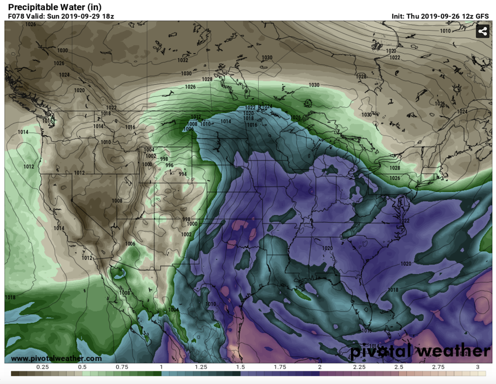
The storm will have ample access to moisture for record-breaking snow totals. 


Vertical temperature profiles will support snow-water ratios increasing to 10:1 or more by early Saturday along the front range, as a deep, DGZ develops aloft, with ample ascent through the profile to support continued development of heavy snow. Model QPF totals are impressive and in good agreement that substantially heavy snow could occur in a localized area along the front range near Waterton/Glacier, with lesser but still significant amounts over the plains to the east – especially as the system departs the Rockies and an area of heavy snow tracks near the international border to the northwest of the surface low. Snowfall totals will vary greatly along the northern fringe of this track, which is one of the factors in the uncertainty of snow totals in the Calgary area. 

A deep dendritic growth zone, as well as deep, easterly flow are indicated on this sounding for Sunday afternoon in extreme SW Alberta, resulting in strong ascent (among other forcing mechanisms) that leads to heavy snow development. Blizzard conditions will be possible across the main area of concern during the latter half of Sunday in particular.


As skies clear out following the passage of the system, strong radiational cooling over the fresh snowpack could lead to a few record low temperatures being set in parts of Alberta and Montana. Indeed, it will suddenly feel as though we have entered a time warp to late November, as persistent troughing across the region will delay the melt and keep things cool into the first part of October! 

Friday, 13 September 2019

That's a Wrap - 2019 Storm Season Highlights!

To date, 2019 was by far my most active. I put on about 40000km between 35 chase days in Canada, and 8 in the US. I logged 12 tornadoes, and got intimate with tennis ball hail near Vulcan. There were some memorable chases, with my favourite one being in Saskatchewan on my birthday (June 27) with friends.

A good chase in Saskatchewan is MONEY, as storms are big, skies are huge, and there are plentiful foreground elements of antiquity for photography. Never turn one down if you get the chance - especially in the south and southwest!

We provided lots of live coverage of storms this season, and documented the aftermath of 3 tornadoes and one straight-line wind event.

Check out these clips if you want to see video of the best stuff:
Highlight Reel and Personal Reflections
2019 Alberta Storm Season Recap

There are numerous considerations that go into determining the value of a given chase, including the rarity of what is seen, storm aesthetics, the amount of time spent taking in those moments, and those you share it with, to name a few. Here are my top 10 chases of 2019, with only one photo from each event selected to represent the day!


#10: Spruce View, AB - July 31. This cyclic supercell had some promising moments, with strong low level rotation in its best cycle. This beefy meso was also one of the better ones of the numerous I saw this summer along the foothills. I'm surprised this one didn't produce a tornado. A weak spinup did occur later in the evening, even though I couldn't see the ground circulation from my location. 


#9: Rainier, AB - July 7. This day over-performed. I began along the Porcupines west of Nanton and tracked it due east, encountering tennis ball hail and a large tornado west of Lomond. One of the best things about this storm was that it tracked through my favourite chase terrain in Alberta - Vulcan County. Open skies, rolling terrain, pristine cropland, and a lack of power poles along many grid roads. 


#8: Dogpound, AB - June 18. Similar to July 21, 2015, but better. All the barber poles you could eat rolled off the foothills NW of Calgary that evening, lined up one after the other. I documented 5 supercells that day, beginning near Eden Valley in the afternoon, and ending near Didsbury. 


#7: Crossfield, AB - July 14. This was a special day, because not only did the storm pop right in our target, but we watched it form from the initial cumuli to the moment it produced a tornado, and beyond. It was really nice sharing that moment with friends. I share this photo because this was really cool to behold - a narrow swath through maturing barley and wheat looked amazing from the air, revealing the snaky tornado track toward our viewing location to the southeast. 


#6: McCook, NE - May 17. We targeted this storm for days, so it was satisfying to see it go. One of the most photogenic tornadoes I've witnessed. 


#5: Carmangay, AB - July 18. I'm glad I told my buddy Glen to go check out the boundary in southern Alberta, as I had a mandatory dance rehearsal for our big Salsa performance at Festival in Calgary, causing me to be late to the party by about an hour. Of course, I was miffed. However, while documenting the aftermath of the tornado, we were able to rescue a kitten from under some sketchy debris and reunite it with a little boy who thought it was a goner. That, and the successful dance performance later made the day more than worth it. 


#4: Alder Flats, AB - July 23. There are a few days each season that really ring the wow meter, and this was one of them. To date, I have never quite seen anything else quite like this. You can almost get a sense of the vacuum-like motion in the storm here even in the still photo - a scene that was impeccably timed and lit by the setting sun. Even though the clouds visually appear to be screaming, it was dead silent aside from the concerned cattle that were bellowing out in the field.


#3: Follett, TX to Laverne, OK - May 23. We thought we had missed the boat on this day, as a large wedge occurred near Canadian on an earlier cycle that was seen by a few chasers to our west. However, it made sense to get ahead of it to see if it would go again, and that it did. Before dark, it became a prolific, long-track tornado producer that dropped more tornadoes of all shapes and sizes than we could accurately count. 


#2: Altus, OK - May 8. This was a "day after the day" chase, with low-topped storms firing in crisp, dry mid and upper levels. At sunset, this made for wonderful scenes - especially after we stumbled upon the Navajo Mountains of southwest Oklahoma. It took Jo and I a long time to pick our jaws up off the fields after seeing this structure. 


#1: Val Marie, SK - June 27. No, not a tornado. We made the decision stick ahead of this linear MCS as it charged east across far southern Saskatchewan at a blistering pace, and boy did it pay. A thick, stratified shelf that looked like it was chiseled out of marble atop marvellous foreground...what more could you ask for?

What were your top chases this year?