Friday, 13 September 2019

That's a Wrap - 2019 Storm Season Highlights!

To date, 2019 was by far my most active. I put on about 40000km between 35 chase days in Canada, and 8 in the US. I logged 12 tornadoes, and got intimate with tennis ball hail near Vulcan. There were some memorable chases, with my favourite one being in Saskatchewan on my birthday (June 27) with friends.

A good chase in Saskatchewan is MONEY, as storms are big, skies are huge, and there are plentiful foreground elements of antiquity for photography. Never turn one down if you get the chance - especially in the south and southwest!

We provided lots of live coverage of storms this season, and documented the aftermath of 3 tornadoes and one straight-line wind event.

Check out these clips if you want to see video of the best stuff:
Highlight Reel and Personal Reflections
2019 Alberta Storm Season Recap

There are numerous considerations that go into determining the value of a given chase, including the rarity of what is seen, storm aesthetics, the amount of time spent taking in those moments, and those you share it with, to name a few. Here are my top 10 chases of 2019, with only one photo from each event selected to represent the day!


#10: Spruce View, AB - July 31. This cyclic supercell had some promising moments, with strong low level rotation in its best cycle. This beefy meso was also one of the better ones of the numerous I saw this summer along the foothills. I'm surprised this one didn't produce a tornado. A weak spinup did occur later in the evening, even though I couldn't see the ground circulation from my location. 


#9: Rainier, AB - July 7. This day over-performed. I began along the Porcupines west of Nanton and tracked it due east, encountering tennis ball hail and a large tornado west of Lomond. One of the best things about this storm was that it tracked through my favourite chase terrain in Alberta - Vulcan County. Open skies, rolling terrain, pristine cropland, and a lack of power poles along many grid roads. 


#8: Dogpound, AB - June 18. Similar to July 21, 2015, but better. All the barber poles you could eat rolled off the foothills NW of Calgary that evening, lined up one after the other. I documented 5 supercells that day, beginning near Eden Valley in the afternoon, and ending near Didsbury. 


#7: Crossfield, AB - July 14. This was a special day, because not only did the storm pop right in our target, but we watched it form from the initial cumuli to the moment it produced a tornado, and beyond. It was really nice sharing that moment with friends. I share this photo because this was really cool to behold - a narrow swath through maturing barley and wheat looked amazing from the air, revealing the snaky tornado track toward our viewing location to the southeast. 


#6: McCook, NE - May 17. We targeted this storm for days, so it was satisfying to see it go. One of the most photogenic tornadoes I've witnessed. 


#5: Carmangay, AB - July 18. I'm glad I told my buddy Glen to go check out the boundary in southern Alberta, as I had a mandatory dance rehearsal for our big Salsa performance at Festival in Calgary, causing me to be late to the party by about an hour. Of course, I was miffed. However, while documenting the aftermath of the tornado, we were able to rescue a kitten from under some sketchy debris and reunite it with a little boy who thought it was a goner. That, and the successful dance performance later made the day more than worth it. 


#4: Alder Flats, AB - July 23. There are a few days each season that really ring the wow meter, and this was one of them. To date, I have never quite seen anything else quite like this. You can almost get a sense of the vacuum-like motion in the storm here even in the still photo - a scene that was impeccably timed and lit by the setting sun. Even though the clouds visually appear to be screaming, it was dead silent aside from the concerned cattle that were bellowing out in the field.


#3: Follett, TX to Laverne, OK - May 23. We thought we had missed the boat on this day, as a large wedge occurred near Canadian on an earlier cycle that was seen by a few chasers to our west. However, it made sense to get ahead of it to see if it would go again, and that it did. Before dark, it became a prolific, long-track tornado producer that dropped more tornadoes of all shapes and sizes than we could accurately count. 


#2: Altus, OK - May 8. This was a "day after the day" chase, with low-topped storms firing in crisp, dry mid and upper levels. At sunset, this made for wonderful scenes - especially after we stumbled upon the Navajo Mountains of southwest Oklahoma. It took Jo and I a long time to pick our jaws up off the fields after seeing this structure. 


#1: Val Marie, SK - June 27. No, not a tornado. We made the decision stick ahead of this linear MCS as it charged east across far southern Saskatchewan at a blistering pace, and boy did it pay. A thick, stratified shelf that looked like it was chiseled out of marble atop marvellous foreground...what more could you ask for?

What were your top chases this year?

Sunday, 21 July 2019

Storm Damage Documentation on the Prairies - Crossfield, Eston, and Carmangay

It has been a very active summer in the prairies, and we aren't done yet. At the time of writing on July 21, Alberta has already surpassed its annual average of 15.4 tornadoes based on the 1980-2009 climatology, which may have already been skewed a little high compared with recent years based on the active 80s.

Here are two tornado events in Alberta and one straight-line wind event in Saskatchewan that occurred in mid-July.

Crossfield, AB - July 14

A classic central Alberta severe weather day was expected on this day, with the focus of severe weather in Alberta expected through "hail alley" - just north of Calgary. A group of us sat just south of Crossfield, and watched as thunderstorms initiated early along the foothills to the west during noon hour. These messy-looking storms would generate an outflow boundary that would drift east toward the QE2 corridor, and become somewhat restrained by large-scale southeasterly flow. Rapid cumulus development ensued, with a line of towering cumuli sitting atop the low level convergence axis - and it didn't take long before we spotted a couple of vorticity funnels along the base. Further north, inflow features began streaming into an increasingly dominant updraft base, with a small notch developing to its west. We repositioned a few kilometres north, before a large funnel appeared in the notch, at the occlusion of a wrapping rear-flank downdraft. It wasn't long before a tornado spun up a couple of miles to our NNW, which wasn't fully condensed - but was associated with a dust whirl at the surface. It quickly became obscured in the rain, but continued for some time. The parent storm fought its outflow as it tracked east, but was the most prolific vorticity funnel producer I've ever witnessed, with several funnels sometimes occurring simultaneously along the shelf generated by the gust front.

The Crossfield tornado. Storm structure reveals it was mesocyclonic, despite numerous other nonmesocyclonic funnels occurring with the storm. 

Based on the damage path, the tornado cut a swath mainly through maturing wheat and barley crops, from NW to SE, beginning at 2:09PM MDT. To this day, it maintains its preliminary EF0 rating. However, damage suggests it could have been slightly more intense in my opinion (EF1), due to a holiday trailer being dragged and thrown 87m (determined by GPS) uphill to the southeast. A lack of damage indicators for vehicles makes an estimate of tornado intensity trickier in this case. The tornado spun up essentially right in the backyard of someone's property, where it sucked a horse trough dry of water, before impacting the RV and flattening a narrow swath of crops to the southeast. The crops would eventually stand up again (as observed in subsequent days), but a high translational speed compared with a relatively low rotational velocity likely resulted in the focused convergent pattern of crop material that was impressive to see firsthand. 

Apparently toilets are well-bolted. They always seem to survive!

Gouge marks are evident where the trailer scraped along the ground, before being deposited in the opposite ditch.

Very impressive track as seen from the air. The track width was no more than 20-30m. 

A close-up of the convergent pattern in bearded wheat.

Here is a link to a story I made for this tornado. 

Eston, SK - July 14

On the same day as the Crossfield tornado, other storms occurred further east across SE Alberta and into Saskatchewan. After abandoning the original Crossfield storm, we tracked another hailer south of Oyen, before noting explosive development of another storm to our east near Eatonia in SW Saskatchewan. This storm would go on to clobber the town of Eston, with street flooding, wind-driven hail that damaged siding, roofs, cars, and crops; and intense straight-line winds that caused significant damage particularly on the SW corner of town.

The storm as seen from the west that would go on to impact the town of Eston. Atom bomb vibes. 

Some folks in town thought a tornado had come through due to how intense the winds were. Others were okay with the official designation of straight-line winds, which have been called "plough winds". In my opinion, the damage incurred suggests at least EF1 intensity (135-175km/h) wind gusts. One resident showed me a video of the storm structure before it impacted the town, which revealed a descending precipitation bomb characteristic of an incipient downburst - and no evidence of funnel clouds. The consistent and widespread west-to-east damage also suggests it was a downburst - though I couldn't determine if it exceeded the scale of the designation of a microburst (damage over a width of <4km). Of note, a hangar at the airport was completely destroyed, with debris being thrown several hundred metres to the east. A 60 foot steel-trussed light tower also bent over at the base, and a roof ripped off one home and slammed into an exterior wall of the next, injuring a woman who was lying in bed at the time (dislocated shoulder). Most impressively was the 2x6 chunk of roof trussing that impaled a home two doors down, protruding into the living room. 

The home with the roof ripped off. 

60 foot metal-trussed tower tipped over

Large grain bins (empty at this time of year) take flight to the east, just west of Eston.

Hail up to the size of golf balls stripped homes of vinyl siding. One home had damage almost right up to the eaves despite having a large overhang, suggesting the hail was coming in almost sideways.

An embedded 2x6. This image sticks with me!

Here is a link to a story I did on this event. 

Carmangay, AB - July 18

Vulcan County has been a lot more active this year than in recent times. For a storm chaser, it is a dream to chase here owing to a decent road network amid rolling terrain, pristine cropland, and excellent visibility. This tornado (like Pine Lake, Three Hills, Jenner 2017, etc) occurred along a boundary in a classic Alberta tornado environment. These kinds of days often don't scream tornado in the days leading up to it, as they are usually post-frontal setups on the cold side of a trough, with messy low level shear profiles and less instability than before the trough came through. However, there is often usually enough residual moisture pooling into the north side of the QS boundary/front, which is impinged by strong, dry W/SW flow across southern Alberta - which can feature an impressive moisture gradient along with a wind shift and associated convergence that supports thunderstorm initiation. Ample instability results on the cool side of the boundary for severe storms amid deep layer shear favourable for updraft rotation (despite the messy low level shear profile) along the cyclonic shear side of the jet, which can support low-topped supercells with storm motions along the front, providing a steady stream of streamwise vorticity for strong low level mesocyclones. The probability of tornadogenesis may also increase in this environment owing to the presence of plentiful environmental low level vertical vorticity along the wind shift line. 

Tornado occurred between 515-530PM MDT. Notice the wind shift, the strong moisture gradient, and the deviant motion to the SE of the parent tornado thunderstorm when updraft rotation was strongest.

Visible satellite and radar trends indicate that the storm itself developed rapidly, as an outflow boundary from a decaying storm to the north collided with the in situ boundary. 

Meteorogram for a nearby ag station reveal the strong, dry westerly flow that preceded the storm. 

The tornado spun up about 17km east of Carmangay in a field just NW of a residence that would become heavily impacted by it - particularly on the northern edge of the property. The home itself sustained some damage, including broken windows, impaling of branches into the home, and some stripped siding and roofing material along with extensive tree damage in the yard. Just north of the home, a well-constructed shop building was destroyed, with a car jack stand inside shifting 10 feet. Anchor bolts were ripped out of the concrete cribbing, and heavy equipment was tossed into the field - including a bale stacker that was thrown 200 metres. At the time of writing, the tornado was given a preliminary rating of EF1 - however, once again in my opinion, some of the damage (that may lack damage indicators for surveyors) suggests EF2 intensity (180-220km/h), and had an estimated (by me) track of over 10km to the SE. A couch cushion was found laying in a field of flattened peas almost 4 kilometres SE, with insulation observed almost 10 kilometres SE. The tornado would thread the needle through wind turbines at the same time that straight-line wind damage was being reported a few kilometres to the west. 

An overview of the property impacted by the tornado. 

Branches impaled into the side of a home, likely from a tree bough being forcefully thrown at it.

The branch coming into the living room.

The destroyed shop. 

Damage that occurred to a barn at the Carmangay Colony to the west. 

The most memorable piece to this story for us however, was the seemingly miraculous survival of some of the animals on the property. As we were doing the survey, we heard something crying from beneath the heap of rubble that had been the shop. We looked inside, and found that it was a tiny Calico kitten. After some careful maneuvers, we were able to retrieve it from the rubble and return it to his owner - a happy little boy. Apparently there had been two, but until that point only one had been accounted for, and all hope for the second was lost. 

Here is "Calico" - who may have used up one of her nine lives. 


The family dog Belle was also seen clawing at the ground outside the basement window as she attempted to avoid getting carried away by the tornado - but to no avail. She got carried away, but somehow returned a while later. 

Belle standing near the wreckage of the shop.

And finally, as we were calculating the distance that the bale stacker was thrown, a little calf came running up behind us crying. Apparently, four calves on the property had their bottle feeder destroyed near the shop, and were looking for food. 


 Here is a link to the kitten rescue, is a link to more of what happened on the property, and here is a link to video of the tornado shot by Sara Banman - the neighbour immediately to the south. She ran for cover after finishing filming.


Thursday, 30 May 2019

May 29 Pyrocumulonimbus Event in Northern Alberta

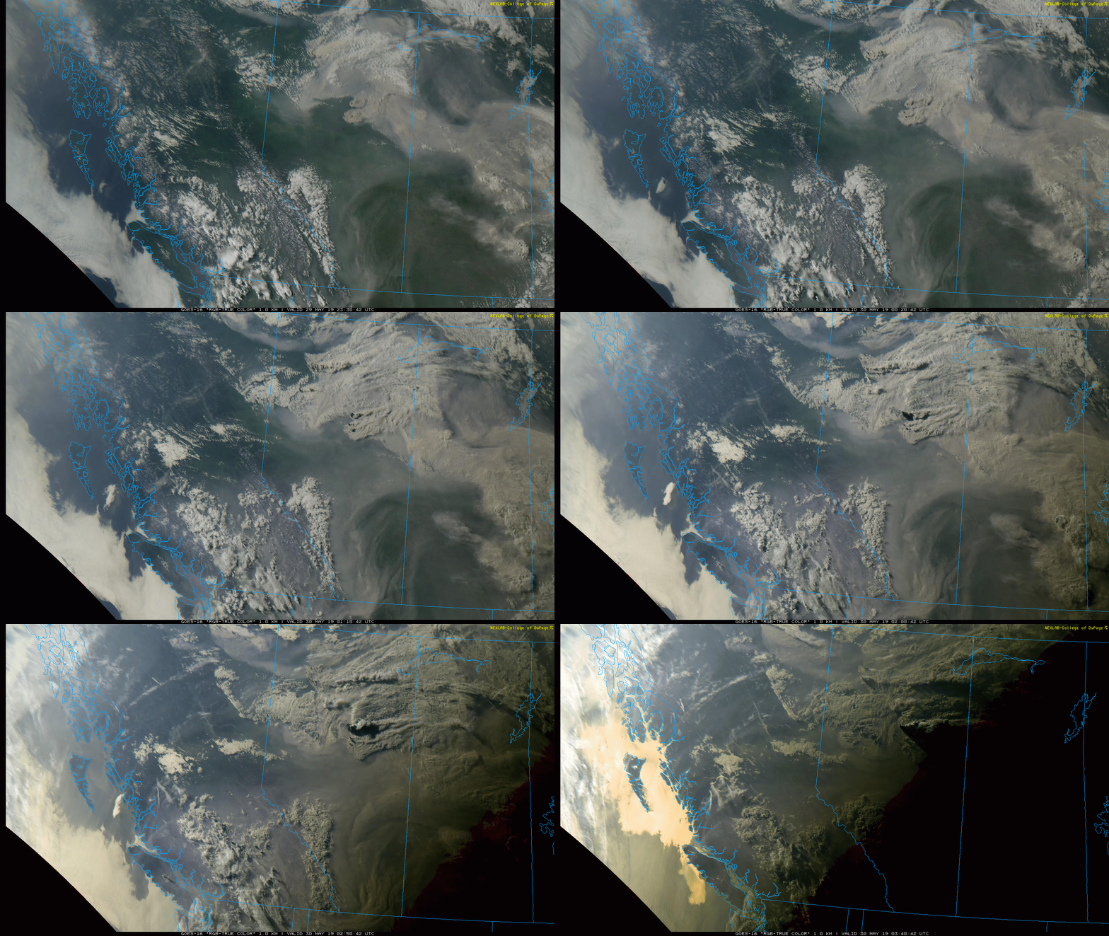
Last night's pyrocumulonimbus event NE of Slave Lake (associated with SWF69 - Maria Lake wildfire) triggered numerous lightning strikes to the east of the fire - as far east as NW Saskatchewan.
As soon as the cap was breached, explosive development resulted in cloud tops to between 30-35Kft based on estimates from IR satellite imagery. 3 new wildfire detections occurred this morning in the vicinity of the greatest cluster of strikes, lending strongly to the hypothesis that they were lightning-caused.

KaBOOM

These are impressive storms, which, like volcanic eruptions, are known to inject aerosols into the stratosphere, where they can linger for months. With a steady increase in pyroCB events according to current climate change trends, one might expect this to begin having a more substantial impact on climate over time. On the storm scale, they can generate CG lightning, strong downdrafts (due to evaporative cooling potential beneath the plume), fire whirls, and can loft burning embers well downwind of the fire, resulting in spotting and new ignitions that are very challenging to control for those engaged in firefighting activities.

An ingredients-based approach similar to one used for forecasting organized severe thunderstorms seems helpful in conceptualizing the development of this (and other) pyroCB events.

First, the large scale environment had to be supportive of both extreme fire behaviour, and the development of deep pyroconvection - and that it was. Dry, cured fuels of considerable depth, combined with hot, dry, and gusty low levels made for the potential of very hot burning fires of considerable intensity. However, this in itself is not enough to generate a pyroCB. The meteorological synoptic background environment would also have to be supportive of deep convection, and it turns out that environments favouring pyroCBs are often the same as those supporting high-based thunderstorms. It's like the "Goldilock's Principle": a deep, well-mixed boundary layer (implying hot near-surface conditions with low RH, as well as steep low level lapse rates) are necessary conditions for extreme fire behaviour, while sufficient instability aloft is also supportive of deep updrafts.

The majority of the boreal region is suffering with extreme fire danger.


"Inverted V" sounding, upstream at YYE just prior to initiation. Locally, would expect to see  greater mid-level RH and perhaps steeper mid-level lapse rates associated with ascent.


The 3 main ingredients for thunderstorms are moisture, instability, and lift (and shear when considering organized convection). Let's apply these here:

Moisture: This would be derived both from the combustion of fuels and attendant release of water vapour, as well as perhaps through entrainment of a layer of moist, mid-level air atop the boundary layer.

Instability: Unstable low levels owing to steep low level lapse rates would result in strong plume dynamics beneath the capping inversion, while steepening mid-level lapse rates associated with PVA from an upstream ridge-riding shortwave trough (and perhaps the proximity to the right entrance region of the upper jet) would erode capping and enable parcels below to burst into the mid and upper troposphere. It would also contribute to convective instability above a moist layer in the mid-levels.

500mb features not well-resolved here, but thermal trough axis exists from NE BC into W NWT,.


Lift: Lift would be generated by thermal buoyancy above the intensely-burning fire itself, amid a background environment where capping could be breached (mentioned above).

Shear: Weak speed and directional shear are needed for robust pyroCBs, unlike organized deep, moist convection such as supercells. With prog soundings showing <20kt of 0-6km shear, as well as initially insignificant low level shear, this criteria was also met.

Observations: Water vapour imagery clearly showed an area of mid-level ascent associated with a shortwave trough sinking southeastward. As soon as this ascent overspread the vicinity of the fire, capping eroded and the smoke plume squirted toward the tropopause. This occurred around 8PM MDT, and lightning flashes were detected almost immediately after. As the pyroCB plume was advected eastward, it would generate over 50 lightning flashes spanning from the near-east side of the fire into NW Saskatchewan.

Notice the cap break as mid-level ascent overspreads the fire. Also, plume is "snipped off" shortly after cold FROPA.


Numerous flashes generally trending from earlier in the west, to later in the east, as pyroCB plume  advects eastward.


The same upper disturbance would support a surface low in NE Alberta that would track SE and bring a trailing cold front southward in its wake. Generation of the pyroCB abruptly ended near 1130PM MDT, and I can think of 2 main reasons for this. First, as the sun sets, the boundary layer decouples as the nocturnal inversion begins to develop- eventually barring further surface-based convection (especially without robust updraft dynamics aloft). But this seems to be a more gradual process. So perhaps the main reason was the establishment of a frontal inversion and attendant low level shear associated with the cold frontal passage, that snipped off the vertical development of the plume.

Red Earth is the nearest station to the NW. Volatile conditions exist during much of the day prior to initiation. Cold front initially appears to be diffuse. 


Wednesday, 1 May 2019

ABSTORM - April 27

On the weekend of April 27-28, a very potent spring storm system moved across southern Alberta and Saskatchewan, bringing all four seasons of weather. Being north of the PFJ, cooler than average weather was already in situ across western Canada. A potent shortwave would ripple through W/NW flow aloft, bringing the strongest forcing for ascent across the region, resulting in unusually strong dynamics. The mass response resulted in strong winds that worked in combination with heavy snowfall rates to create blizzard conditions Saturday evening and into Sunday morning across SW Saskatchewan. Also of note was locally enhanced precipitation rates in areas where terrain acted to enhance lift - even near gradual rises in the land where there was only 100-200m of difference in elevation over several kilometres. Blizzard warnings were in place across much of the south, with winter storm warnings to the west along the southern foothills including Calgary, and snowfall warnings further northwest. For the 3 severe thunderstorm warnings issued in the SE in the afternoon, they would have also had concurrent blizzard warnings. Cool!

500mb analysis at 12Z Saturday reveals the main trough is still back near northern Vancouver Island at this time.


We decided to get a taste for all of it - with the hopes of hearing our first thunder of 2019 in the afternoon. Darren and I left Calgary at 8AM and headed for the nearest snow - which had set up in a near-stationary band NE of the city, which trended NW into central AB, causing havoc on roads there. In Drumheller, it was snowing heavily, but it was very wet. Water was gushing out of the badlands near the hoodoos SE of town. In the valley bottom, the snow was hardly sticking - unlike at ridgetop. After doing a few soggy hits for TV, we headed south on 56 toward HWY 1, and encountered gradually worsening road conditions. Very strong SE flow and enhanced snowfall rates were covering the road with drifts a foot deep in places, and we saw a few vehicles in the ditch while white-knuckling and fish-tailing ourselves. It turns out the worst of it was on the south slope of a W-E trending ridge south of Drumheller, and the ploughs were only going as far north as Hussar. Just north of the town was the worst, but then it rapidly improved as we passed the town. By the time we hit Bassano, there was only a trace of snow on the ground.

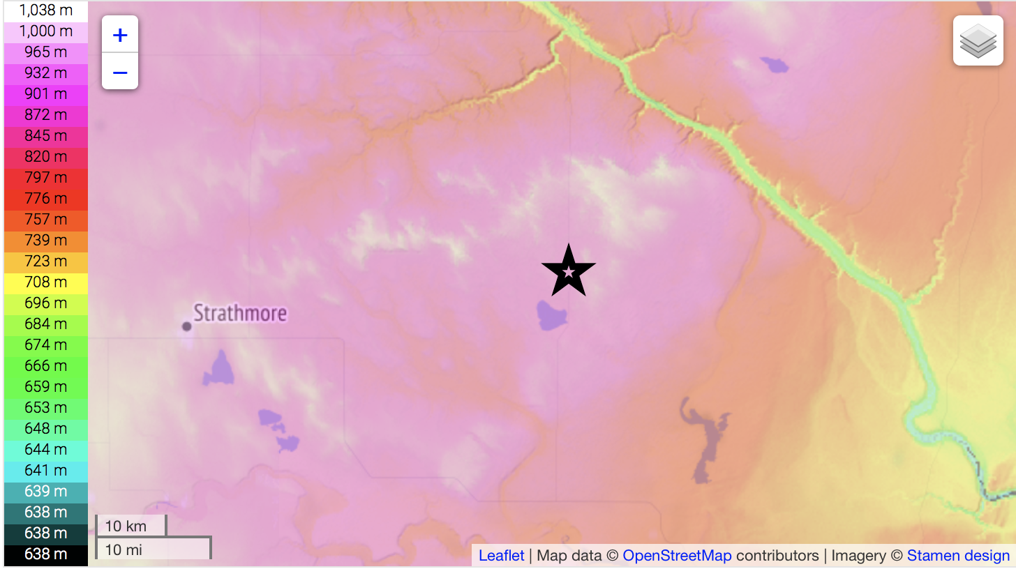
The star is where roads were worst, just north of Hussar. The ridge just north is about 200m higher than the terrain near the Crawling Valley Reservoir about 30km to the SE.


Only 63km SE of the location where the roads were the worst, and not an hour later, we were in patches of sun and had temperatures of 8/4, with no snow anywhere to be seen. Towering CU were billowing up all around and within minutes, we observed our first vivid CG strikes from a developing storm near the 36/1 intersection. These storms had pleasantly low LCLs and were drifting slowly NW, in an environment of locally pooled moisture and rich vorticity near the surface low. This was a promising area to see funnel clouds, and the clear thunderstorm target. Then, less than an hour after nearly sliding into the ditch in deep snow, we witnessed a funnel cloud that lasted a little over a minute, as 12mm hail was falling around us in a rest area where numerous others were pulled over.

Funnel cloud, which occurred at around 1913Z.

18Z surface obs. Note the clear slot into SW AB. Very cold air aloft began to advect over the narrow moist axis around midday, leading to significant destabilization. 8/4 can get it done in Alberta!

After the funnel dissipated, we sat in the same location watching the cloud bases for at least another half hour, as hail piled up on the road surface around us (to over 10cm), and slowly increased in size. We reported 17.5mm hail, and shortly after, the storm went severe warned. Cars started sliding into the ditch once again as a result of the hail. 

Hail covers the road on the TCH at the rest stop just west of 36.


We then went and did a few more TV hits, before having a late lunch in Brooks for a much-appreciated break. Just as we finished a second storm developed south of town, so we intercepted it in Rolling Hills, before heading around the road hole toward Suffield to catch it as it slowly drifted across. Strong E/NE surface flow with still-decent moisture continued feeding the storm and restraining its outflow, with new updraft bases developing on the eastern flanks in cycles. As the bases began to precipitate, lightning activity would ramp up. Almost like clockwork, we observed a sizeable flash of lightning every 20 seconds or so, with many CGs. It was a very good first storm! Eventually, we abandoned it as it fizzled, and headed back NW. Along the way, we crossed the still-melting hail swath from the first storm and found it to be very localized - taking about 40 seconds to transect at highway speed. Then, it was on to the blizzard.

Video screenshot of a nice CG we caught to our SW.


First, we were hit by blasting northerly flow behind the cold front somewhere between Bassano and Gleichen, where Darren was observing gusts on the Kestrel of over 30 knots. Some snow was being lofted but the area had very little on the ground, with the heaviest precipitation bands still to the north. As we got heading west into Strathmore on the final stretch, we began to encounter whiteout conditions - as there was much more snow on the ground in the area. The temperature was still 0-1C, so I couldn't imagine how much more snow would drift if colder.

Also a video screenshot of the blizzard conditions in Strathmore.


The highway toward Calgary was shut owing to an "80-100 car pile-up" in Chestermere, so we had dinner at BP's under flickering lights as the storm raged outside. We also shot some decent footage in town, before finding a ninja way back with no one else on it all the way to the city, arriving near midnight.

Our stops for the day. 


The storm would dump 30cm along the central foothills, 35-40cm across far SW Saskatchewan, and possibly more locally along the north slope of the Cypress Hills. Winds would gust in excess of 100km/h across southern Alberta into the overnight, and very cold conditions would follow the system in the days to come. Despite travel woes, the moisture was much appreciated across the region.

It was a truly memorable day for both of us, with exciting driving conditions, two severe warned storms, a funnel cloud, hail, and the worst blizzard I've seen - all in a late April day's work.

Get a load of this. 


Here is a link to our visuals and a summary of the storm:
https://www.theweathernetwork.com/ca/videos/gallery/revisit-some-of-the-amazing-scenes-of-snow-lightning-and-hail-from-alberta-this-weekend/5802443044001/6030852532001/forecasts

Additional progs:

The system didn't have excellent moisture availability, but enough was able to pool to lead to probably 500J./kg of MLCAPE along the moist axis. Severe warned storms occurred on our Brooks and Ralston storms, with another one near the Hat. 

Frigid 700mb temps, and an environment supportive of funnel clouds. 

Low and mid-level lapse rates were quite steep as a result of surface heating beneath rapid cooling aloft.

850mb winds reveal how strong the dynamics were with this compact little system.